You are here: Home > Network List > BE - Belgian Seismic Network Stations List
> Station MEM Membach, Belgium > Earthquake Result Viewer
MEM Membach, Belgium - Earthquake Result Viewer
| Earthquake location: |
Myanmar |
| Earthquake latitude/longitude: |
20.9/94.6 |
| Earthquake time(UTC): |
2016/08/24 (237) 10:34:55 GMT |
| Earthquake Depth: |
84 km |
| Earthquake Magnitude: |
6.8 MO |
| Earthquake Catalog/Contributor: |
NEIC PDE/NEIC ALERT |
|
| Network: |
BE Belgian Seismic Network |
| Station: |
MEM Membach, Belgium |
| Lat/Lon: |
50.61 N/6.01 E |
| Elevation: |
250 m |
|
| Distance: |
73.2 deg |
| Az: |
318.301 deg |
| Baz: |
77.441 deg |
| Ray Param: |
0.05294469 |
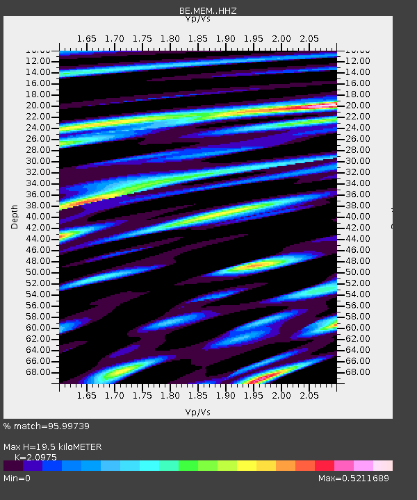
| Estimated Moho Depth: |
19.5 km |
| Estimated Crust Vp/Vs: |
2.10 |
| Assumed Crust Vp: |
6.276 km/s |
| Estimated Crust Vs: |
2.992 km/s |
| Estimated Crust Poisson's Ratio: |
0.35 |
|
| Radial Match: |
95.99739 % |
| Radial Bump: |
400 |
| Transverse Match: |
83.10231 % |
| Transverse Bump: |
400 |
| SOD ConfigId: |
11737051 |
| Insert Time: |
2019-04-25 08:48:25.868 +0000 |
| GWidth: |
2.5 |
| Max Bumps: |
400 |
| Tol: |
0.001 |
|

Signal To Noise
| Channel | StoN | STA | LTA |
| BE:MEM: :HHZ:20160824T10:45:45.877991Z | 31.676508 | 1.9484876E-6 | 6.151207E-8 |
| BE:MEM: :HHN:20160824T10:45:45.877991Z | 3.4146473 | 3.1283992E-7 | 9.1617046E-8 |
| BE:MEM: :HHE:20160824T10:45:45.877991Z | 13.297944 | 7.430433E-7 | 5.587656E-8 |
| Arrivals |
| Ps | 3.5 SECOND |
| PpPs | 9.4 SECOND |
| PsPs/PpSs | 13 SECOND |


