You are here: Home > Network List > DK - Danish Seismological Network Stations List
> Station DBG Daneborg, Greenland > Earthquake Result Viewer
DBG Daneborg, Greenland - Earthquake Result Viewer

| Earthquake location: |
Myanmar |
| Earthquake latitude/longitude: |
20.9/94.6 |
| Earthquake time(UTC): |
2016/08/24 (237) 10:34:55 GMT |
| Earthquake Depth: |
84 km |
| Earthquake Magnitude: |
6.8 MO |
| Earthquake Catalog/Contributor: |
NEIC PDE/NEIC ALERT |
|
| Network: |
DK Danish Seismological Network |
| Station: |
DBG Daneborg, Greenland |
| Lat/Lon: |
74.31 N/20.22 W |
| Elevation: |
1.0 m |
|
| Distance: |
76.4 deg |
| Az: |
345.275 deg |
| Baz: |
60.82 deg |
| Ray Param: |
0.05082181 |
| Estimated Moho Depth: |
37.25 km |
| Estimated Crust Vp/Vs: |
2.02 |
| Assumed Crust Vp: |
6.459 km/s |
| Estimated Crust Vs: |
3.206 km/s |
| Estimated Crust Poisson's Ratio: |
0.34 |
|
| Radial Match: |
90.25668 % |
| Radial Bump: |
398 |
| Transverse Match: |
79.83635 % |
| Transverse Bump: |
400 |
| SOD ConfigId: |
11737051 |
| Insert Time: |
2019-04-25 08:49:08.478 +0000 |
| GWidth: |
2.5 |
| Max Bumps: |
400 |
| Tol: |
0.001 |
|
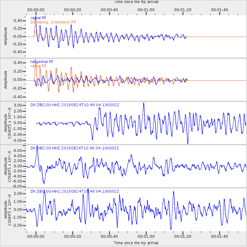
Signal To Noise
| Channel | StoN | STA | LTA |
| DK:DBG:00:HHZ:20160824T10:46:04.190002Z | 22.201157 | 4.002767E-6 | 1.8029543E-7 |
| DK:DBG:00:HH1:20160824T10:46:04.190002Z | 10.179046 | 1.2321018E-6 | 1.2104294E-7 |
| DK:DBG:00:HH2:20160824T10:46:04.190002Z | 9.533167 | 1.5098562E-6 | 1.583793E-7 |
| Arrivals |
| Ps | 6.0 SECOND |
| PpPs | 17 SECOND |
| PsPs/PpSs | 23 SECOND |


