You are here: Home > Network List > DK - Danish Seismological Network Stations List
> Station NOR Station Nord, Greenland > Earthquake Result Viewer
NOR Station Nord, Greenland - Earthquake Result Viewer
| Earthquake location: |
Myanmar |
| Earthquake latitude/longitude: |
20.9/94.6 |
| Earthquake time(UTC): |
2016/08/24 (237) 10:34:55 GMT |
| Earthquake Depth: |
84 km |
| Earthquake Magnitude: |
6.8 MO |
| Earthquake Catalog/Contributor: |
NEIC PDE/NEIC ALERT |
|
| Network: |
DK Danish Seismological Network |
| Station: |
NOR Station Nord, Greenland |
| Lat/Lon: |
81.60 N/16.66 W |
| Elevation: |
36 m |
|
| Distance: |
72.5 deg |
| Az: |
351.74 deg |
| Baz: |
66.043 deg |
| Ray Param: |
0.053451333 |
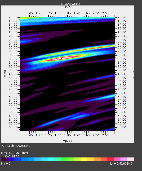
| Estimated Moho Depth: |
31.5 km |
| Estimated Crust Vp/Vs: |
1.82 |
| Assumed Crust Vp: |
6.459 km/s |
| Estimated Crust Vs: |
3.554 km/s |
| Estimated Crust Poisson's Ratio: |
0.28 |
|
| Radial Match: |
90.03349 % |
| Radial Bump: |
400 |
| Transverse Match: |
86.28913 % |
| Transverse Bump: |
400 |
| SOD ConfigId: |
11737051 |
| Insert Time: |
2019-04-25 08:49:12.739 +0000 |
| GWidth: |
2.5 |
| Max Bumps: |
400 |
| Tol: |
0.001 |
|

Signal To Noise
| Channel | StoN | STA | LTA |
| DK:NOR: :HHZ:20160824T10:45:41.338989Z | 86.62116 | 5.6345784E-6 | 6.504852E-8 |
| DK:NOR: :HHN:20160824T10:45:41.338989Z | 7.504394 | 5.6433083E-7 | 7.5200056E-8 |
| DK:NOR: :HHE:20160824T10:45:41.338989Z | 30.672495 | 1.7122545E-6 | 5.582378E-8 |
| Arrivals |
| Ps | 4.1 SECOND |
| PpPs | 13 SECOND |
| PsPs/PpSs | 17 SECOND |


