You are here: Home > Network List > EI - Irish National Seismic Network (INSN) Stations List
> Station VAL Valentia > Earthquake Result Viewer
VAL Valentia - Earthquake Result Viewer
| Earthquake location: |
Myanmar |
| Earthquake latitude/longitude: |
20.9/94.6 |
| Earthquake time(UTC): |
2016/08/24 (237) 10:34:55 GMT |
| Earthquake Depth: |
84 km |
| Earthquake Magnitude: |
6.8 MO |
| Earthquake Catalog/Contributor: |
NEIC PDE/NEIC ALERT |
|
| Network: |
EI Irish National Seismic Network (INSN) |
| Station: |
VAL Valentia |
| Lat/Lon: |
51.94 N/10.24 W |
| Elevation: |
14 m |
|
| Distance: |
82.5 deg |
| Az: |
322.869 deg |
| Baz: |
65.726 deg |
| Ray Param: |
0.046677057 |
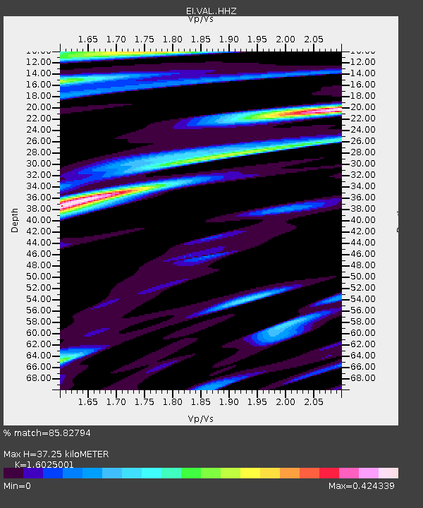
| Estimated Moho Depth: |
37.25 km |
| Estimated Crust Vp/Vs: |
1.60 |
| Assumed Crust Vp: |
6.24 km/s |
| Estimated Crust Vs: |
3.894 km/s |
| Estimated Crust Poisson's Ratio: |
0.18 |
|
| Radial Match: |
85.82794 % |
| Radial Bump: |
388 |
| Transverse Match: |
57.061474 % |
| Transverse Bump: |
400 |
| SOD ConfigId: |
11737051 |
| Insert Time: |
2019-04-25 08:49:16.908 +0000 |
| GWidth: |
2.5 |
| Max Bumps: |
400 |
| Tol: |
0.001 |
|

Signal To Noise
| Channel | StoN | STA | LTA |
| EI:VAL: :HHZ:20160824T10:46:37.01001Z | 3.6390758 | 2.4013882E-6 | 6.598896E-7 |
| EI:VAL: :HHN:20160824T10:46:37.01001Z | 0.9671513 | 4.846786E-7 | 5.011404E-7 |
| EI:VAL: :HHE:20160824T10:46:37.01001Z | 1.6300328 | 6.769369E-7 | 4.1529037E-7 |
| Arrivals |
| Ps | 3.7 SECOND |
| PpPs | 15 SECOND |
| PsPs/PpSs | 19 SECOND |


