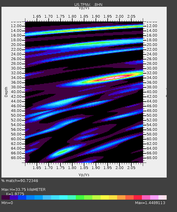
TPNV Topopah Spring, Nevada, USA - Earthquake Result Viewer
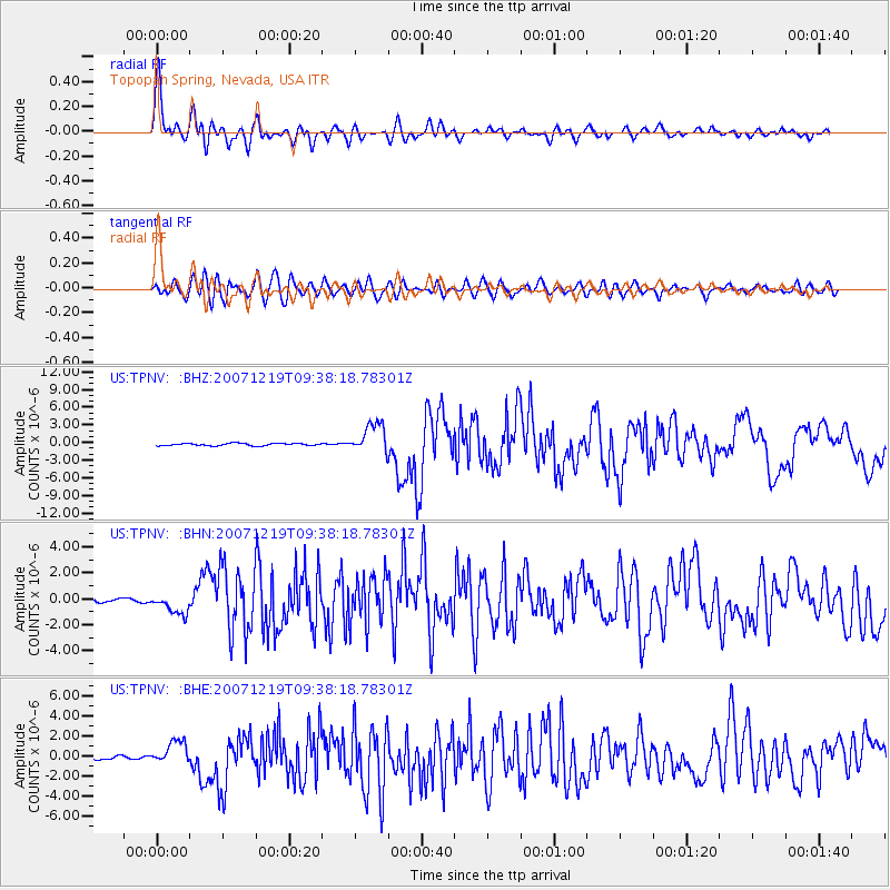
Earthquake location: Andreanof Islands, Aleutian Is.
Earthquake latitude/longitude: 51.4/-179.5
Earthquake time(UTC): 2007/12/19 (353) 09:30:27 GMT
Earthquake Depth: 29 km
Earthquake Magnitude: 6.4 MB, 7.1 MS, 7.1 MW, 7.0 MW
Earthquake Catalog/Contributor: WHDF/NEIC
Network: US United States National Seismic Network
Station: TPNV Topopah Spring, Nevada, USA
Lat/Lon: 36.95 N/116.25 W
Elevation: 1600 m
Distance: 46.2 deg
Az: 82.473 deg
Baz: 309.118 deg
Ray Param: 0.0707406
Estimated Moho Depth: 33.75 km
Estimated Crust Vp/Vs: 1.98
Assumed Crust Vp: 6.279 km/s
Estimated Crust Vs: 3.175 km/s
Estimated Crust Poisson's Ratio: 0.33
Radial Match: 90.72346 %
Radial Bump: 400
Transverse Match: 76.48976 %
Transverse Bump: 400
SOD ConfigId: 2564
Insert Time: 2010-03-05 06:26:34.413 +0000
GWidth: 2.5
Max Bumps: 400
Tol: 0.001

Signal To Noise

ChannelStoNSTALTA
US:TPNV: :BHN:20071219T09:38:18.78301Z4.0607898.249765E-72.0315669E-7
US:TPNV: :BHE:20071219T09:38:18.78301Z4.27427961.1742942E-62.74735E-7
US:TPNV: :BHZ:20071219T09:38:18.78301Z12.4998042.5628717E-62.0503296E-7
Arrivals
Ps5.5 SECOND
PpPs15 SECOND
PsPs/PpSs21 SECOND