You are here: Home > Network List > GB - Great Britain Seismograph Network Stations List
> Station JSA ST AUBINS, JERSEY > Earthquake Result Viewer
JSA ST AUBINS, JERSEY - Earthquake Result Viewer
| Earthquake location: |
Myanmar |
| Earthquake latitude/longitude: |
20.9/94.6 |
| Earthquake time(UTC): |
2016/08/24 (237) 10:34:55 GMT |
| Earthquake Depth: |
84 km |
| Earthquake Magnitude: |
6.8 MO |
| Earthquake Catalog/Contributor: |
NEIC PDE/NEIC ALERT |
|
| Network: |
GB Great Britain Seismograph Network |
| Station: |
JSA ST AUBINS, JERSEY |
| Lat/Lon: |
49.19 N/2.17 W |
| Elevation: |
39 m |
|
| Distance: |
78.7 deg |
| Az: |
318.363 deg |
| Baz: |
71.213 deg |
| Ray Param: |
0.04927655 |
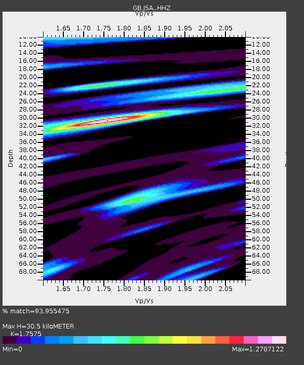
| Estimated Moho Depth: |
30.5 km |
| Estimated Crust Vp/Vs: |
1.76 |
| Assumed Crust Vp: |
6.24 km/s |
| Estimated Crust Vs: |
3.55 km/s |
| Estimated Crust Poisson's Ratio: |
0.26 |
|
| Radial Match: |
93.955475 % |
| Radial Bump: |
366 |
| Transverse Match: |
83.4644 % |
| Transverse Bump: |
400 |
| SOD ConfigId: |
11737051 |
| Insert Time: |
2019-04-25 08:49:33.810 +0000 |
| GWidth: |
2.5 |
| Max Bumps: |
400 |
| Tol: |
0.001 |
|

Signal To Noise
| Channel | StoN | STA | LTA |
| GB:JSA: :HHZ:20160824T10:46:16.890015Z | 11.763078 | 1.8987038E-6 | 1.6141216E-7 |
| GB:JSA: :HHN:20160824T10:46:16.890015Z | 1.6122566 | 2.9727525E-7 | 1.8438458E-7 |
| GB:JSA: :HHE:20160824T10:46:16.890015Z | 4.348763 | 7.1932675E-7 | 1.654095E-7 |
| Arrivals |
| Ps | 3.8 SECOND |
| PpPs | 13 SECOND |
| PsPs/PpSs | 17 SECOND |


