You are here: Home > Network List > GB - Great Britain Seismograph Network Stations List
> Station IOMK KIRK MICHAEL, ISLE OF MAN > Earthquake Result Viewer
IOMK KIRK MICHAEL, ISLE OF MAN - Earthquake Result Viewer
| Earthquake location: |
Myanmar |
| Earthquake latitude/longitude: |
20.9/94.6 |
| Earthquake time(UTC): |
2016/08/24 (237) 10:34:55 GMT |
| Earthquake Depth: |
84 km |
| Earthquake Magnitude: |
6.8 MO |
| Earthquake Catalog/Contributor: |
NEIC PDE/NEIC ALERT |
|
| Network: |
GB Great Britain Seismograph Network |
| Station: |
IOMK KIRK MICHAEL, ISLE OF MAN |
| Lat/Lon: |
54.26 N/4.57 W |
| Elevation: |
188 m |
|
| Distance: |
78.4 deg |
| Az: |
323.757 deg |
| Baz: |
70.405 deg |
| Ray Param: |
0.049453504 |
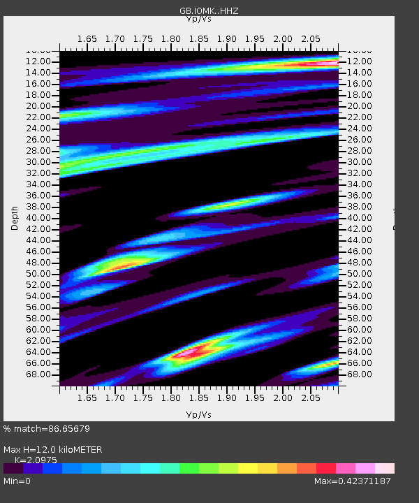
| Estimated Moho Depth: |
12.0 km |
| Estimated Crust Vp/Vs: |
2.10 |
| Assumed Crust Vp: |
6.276 km/s |
| Estimated Crust Vs: |
2.992 km/s |
| Estimated Crust Poisson's Ratio: |
0.35 |
|
| Radial Match: |
86.65679 % |
| Radial Bump: |
291 |
| Transverse Match: |
66.129395 % |
| Transverse Bump: |
400 |
| SOD ConfigId: |
11737051 |
| Insert Time: |
2019-04-25 08:49:33.857 +0000 |
| GWidth: |
2.5 |
| Max Bumps: |
400 |
| Tol: |
0.001 |
|

Signal To Noise
| Channel | StoN | STA | LTA |
| GB:IOMK: :HHZ:20160824T10:46:15.450012Z | 5.176301 | 1.0058341E-5 | 1.9431525E-6 |
| GB:IOMK: :HHN:20160824T10:46:15.450012Z | 1.289802 | 2.3015664E-6 | 1.7844338E-6 |
| GB:IOMK: :HHE:20160824T10:46:15.450012Z | 3.5315146 | 3.6630222E-6 | 1.0372383E-6 |
| Arrivals |
| Ps | 2.1 SECOND |
| PpPs | 5.8 SECOND |
| PsPs/PpSs | 7.9 SECOND |


