You are here: Home > Network List > US - United States National Seismic Network Stations List
> Station TPNV Topopah Spring, Nevada, USA > Earthquake Result Viewer
TPNV Topopah Spring, Nevada, USA - Earthquake Result Viewer
| Earthquake location: |
Peru-Ecuador Border Region |
| Earthquake latitude/longitude: |
-2.3/-77.8 |
| Earthquake time(UTC): |
2007/11/16 (320) 03:13:00 GMT |
| Earthquake Depth: |
123 km |
| Earthquake Magnitude: |
6.3 MB, 6.8 MW, 6.7 MW |
| Earthquake Catalog/Contributor: |
WHDF/NEIC |
|
| Network: |
US United States National Seismic Network |
| Station: |
TPNV Topopah Spring, Nevada, USA |
| Lat/Lon: |
36.95 N/116.25 W |
| Elevation: |
1600 m |
|
| Distance: |
52.9 deg |
| Az: |
321.386 deg |
| Baz: |
128.888 deg |
| Ray Param: |
0.06605081 |
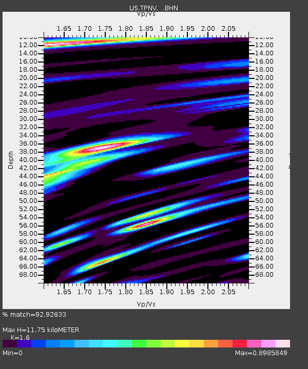
| Estimated Moho Depth: |
11.75 km |
| Estimated Crust Vp/Vs: |
1.60 |
| Assumed Crust Vp: |
6.279 km/s |
| Estimated Crust Vs: |
3.924 km/s |
| Estimated Crust Poisson's Ratio: |
0.18 |
|
| Radial Match: |
92.92633 % |
| Radial Bump: |
400 |
| Transverse Match: |
81.02243 % |
| Transverse Bump: |
400 |
| SOD ConfigId: |
2564 |
| Insert Time: |
2010-03-05 06:26:39.631 +0000 |
| GWidth: |
2.5 |
| Max Bumps: |
400 |
| Tol: |
0.001 |
|
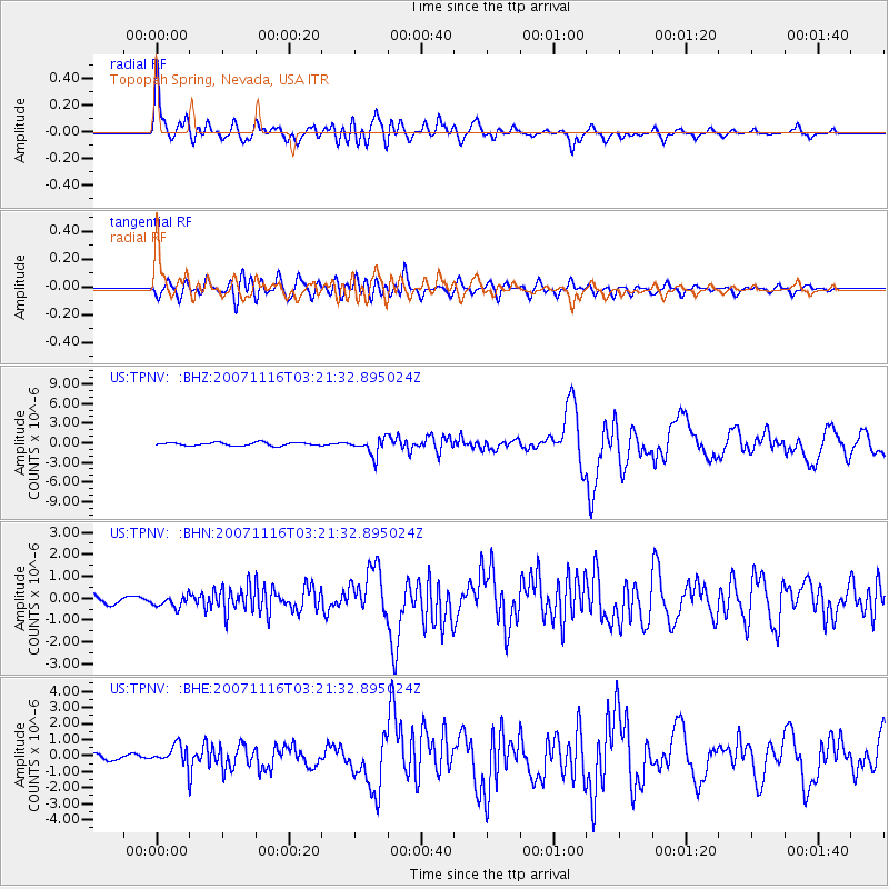
Signal To Noise
| Channel | StoN | STA | LTA |
| US:TPNV: :BHN:20071116T03:21:32.895024Z | 1.578633 | 2.6555122E-7 | 1.6821593E-7 |
| US:TPNV: :BHE:20071116T03:21:32.895024Z | 3.1585522 | 5.937548E-7 | 1.8798322E-7 |
| US:TPNV: :BHZ:20071116T03:21:32.895024Z | 5.5616913 | 1.3309065E-6 | 2.3929888E-7 |
| Arrivals |
| Ps | 1.2 SECOND |
| PpPs | 4.6 SECOND |
| PsPs/PpSs | 5.8 SECOND |


