You are here: Home > Network List > GG - Greenland Ice Sheet Monitoring Network Stations List
> Station SE1 Kagssortoq, Greenland > Earthquake Result Viewer
SE1 Kagssortoq, Greenland - Earthquake Result Viewer
| Earthquake location: |
Myanmar |
| Earthquake latitude/longitude: |
20.9/94.6 |
| Earthquake time(UTC): |
2016/08/24 (237) 10:34:55 GMT |
| Earthquake Depth: |
84 km |
| Earthquake Magnitude: |
6.8 MO |
| Earthquake Catalog/Contributor: |
NEIC PDE/NEIC ALERT |
|
| Network: |
GG Greenland Ice Sheet Monitoring Network |
| Station: |
SE1 Kagssortoq, Greenland |
| Lat/Lon: |
63.25 N/42.03 W |
| Elevation: |
23 m |
|
| Distance: |
89.5 deg |
| Az: |
341.889 deg |
| Baz: |
39.957 deg |
| Ray Param: |
0.041725945 |
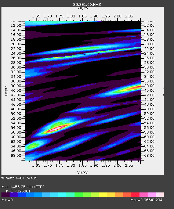
| Estimated Moho Depth: |
56.25 km |
| Estimated Crust Vp/Vs: |
1.73 |
| Assumed Crust Vp: |
6.424 km/s |
| Estimated Crust Vs: |
3.708 km/s |
| Estimated Crust Poisson's Ratio: |
0.25 |
|
| Radial Match: |
84.74485 % |
| Radial Bump: |
400 |
| Transverse Match: |
73.17175 % |
| Transverse Bump: |
400 |
| SOD ConfigId: |
11737051 |
| Insert Time: |
2019-04-25 08:49:51.070 +0000 |
| GWidth: |
2.5 |
| Max Bumps: |
400 |
| Tol: |
0.001 |
|
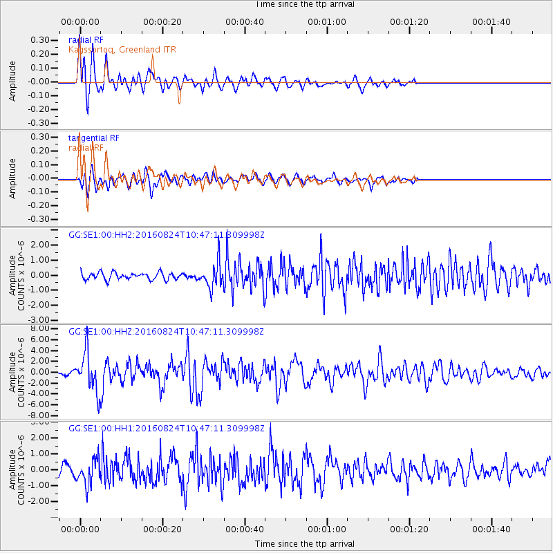
Signal To Noise
| Channel | StoN | STA | LTA |
| GG:SE1:00:HHZ:20160824T10:47:11.309998Z | 10.139859 | 3.8217486E-6 | 3.769035E-7 |
| GG:SE1:00:HH1:20160824T10:47:11.309998Z | 2.1838 | 7.839493E-7 | 3.58984E-7 |
| GG:SE1:00:HH2:20160824T10:47:11.309998Z | 3.8960185 | 8.941756E-7 | 2.295101E-7 |
| Arrivals |
| Ps | 6.6 SECOND |
| PpPs | 23 SECOND |
| PsPs/PpSs | 30 SECOND |


