You are here: Home > Network List > US - United States National Seismic Network Stations List
> Station TPNV Topopah Spring, Nevada, USA > Earthquake Result Viewer
TPNV Topopah Spring, Nevada, USA - Earthquake Result Viewer
| Earthquake location: |
Near Coast Of Peru |
| Earthquake latitude/longitude: |
-13.3/-76.5 |
| Earthquake time(UTC): |
2007/08/16 (228) 00:02:41 GMT |
| Earthquake Depth: |
40 km |
| Earthquake Magnitude: |
5.6 MB |
| Earthquake Catalog/Contributor: |
WHDF/NEIC |
|
| Network: |
US United States National Seismic Network |
| Station: |
TPNV Topopah Spring, Nevada, USA |
| Lat/Lon: |
36.95 N/116.25 W |
| Elevation: |
1600 m |
|
| Distance: |
62.4 deg |
| Az: |
324.679 deg |
| Baz: |
135.355 deg |
| Ray Param: |
0.06017438 |
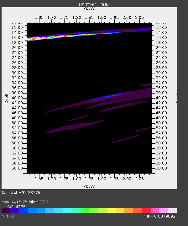
| Estimated Moho Depth: |
15.75 km |
| Estimated Crust Vp/Vs: |
1.68 |
| Assumed Crust Vp: |
6.279 km/s |
| Estimated Crust Vs: |
3.743 km/s |
| Estimated Crust Poisson's Ratio: |
0.22 |
|
| Radial Match: |
91.387764 % |
| Radial Bump: |
400 |
| Transverse Match: |
56.791435 % |
| Transverse Bump: |
320 |
| SOD ConfigId: |
2564 |
| Insert Time: |
2010-03-05 06:26:56.209 +0000 |
| GWidth: |
2.5 |
| Max Bumps: |
400 |
| Tol: |
0.001 |
|
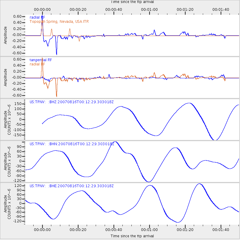
Signal To Noise
| Channel | StoN | STA | LTA |
| US:TPNV: :BHN:20070816T00:12:29.303018Z | 1.1358727 | 5.5038392E-5 | 4.845472E-5 |
| US:TPNV: :BHE:20070816T00:12:29.303018Z | 2.9173737 | 7.227803E-5 | 2.4775032E-5 |
| US:TPNV: :BHZ:20070816T00:12:29.303018Z | 1.5937282 | 6.5599226E-5 | 4.1160863E-5 |
| Arrivals |
| Ps | 1.8 SECOND |
| PpPs | 6.4 SECOND |
| PsPs/PpSs | 8.2 SECOND |


