You are here: Home > Network List > OX - North-East Italy Seismic Network Stations List
> Station FUSE Fusea > Earthquake Result Viewer
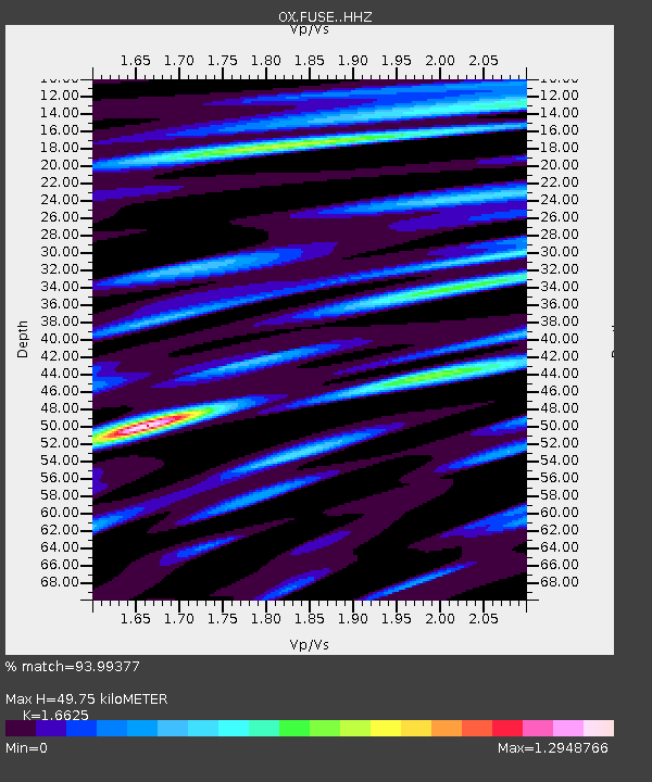
FUSE Fusea - Earthquake Result Viewer
| Earthquake location: |
Myanmar |
| Earthquake latitude/longitude: |
20.9/94.6 |
| Earthquake time(UTC): |
2016/08/24 (237) 10:34:55 GMT |
| Earthquake Depth: |
84 km |
| Earthquake Magnitude: |
6.8 MO |
| Earthquake Catalog/Contributor: |
NEIC PDE/NEIC ALERT |
|
| Network: |
OX North-East Italy Seismic Network |
| Station: |
FUSE Fusea |
| Lat/Lon: |
46.41 N/13.00 E |
| Elevation: |
520 m |
|
| Distance: |
69.4 deg |
| Az: |
313.037 deg |
| Baz: |
80.985 deg |
| Ray Param: |
0.05543484 |
| Estimated Moho Depth: |
49.75 km |
| Estimated Crust Vp/Vs: |
1.66 |
| Assumed Crust Vp: |
6.35 km/s |
| Estimated Crust Vs: |
3.82 km/s |
| Estimated Crust Poisson's Ratio: |
0.22 |
|
| Radial Match: |
93.99377 % |
| Radial Bump: |
400 |
| Transverse Match: |
80.126686 % |
| Transverse Bump: |
400 |
| SOD ConfigId: |
11737051 |
| Insert Time: |
2019-04-25 08:51:03.920 +0000 |
| GWidth: |
2.5 |
| Max Bumps: |
400 |
| Tol: |
0.001 |
|

Signal To Noise
| Channel | StoN | STA | LTA |
| OX:FUSE: :HHZ:20160824T10:45:23.127991Z | 24.927366 | 1.6542423E-6 | 6.6362496E-8 |
| OX:FUSE: :HHN:20160824T10:45:23.127991Z | 3.923605 | 2.435238E-7 | 6.206634E-8 |
| OX:FUSE: :HHE:20160824T10:45:23.127991Z | 16.900173 | 6.2483997E-7 | 3.6972402E-8 |
| Arrivals |
| Ps | 5.4 SECOND |
| PpPs | 20 SECOND |
| PsPs/PpSs | 25 SECOND |


