You are here: Home > Network List > S - Seismographs in Schools Projects Stations List
> Station AULHS Lilydale High School, Lilydale, TAS > Earthquake Result Viewer
AULHS Lilydale High School, Lilydale, TAS - Earthquake Result Viewer
| Earthquake location: |
Myanmar |
| Earthquake latitude/longitude: |
20.9/94.6 |
| Earthquake time(UTC): |
2016/08/24 (237) 10:34:55 GMT |
| Earthquake Depth: |
84 km |
| Earthquake Magnitude: |
6.8 MO |
| Earthquake Catalog/Contributor: |
NEIC PDE/NEIC ALERT |
|
| Network: |
S Seismographs in Schools Projects |
| Station: |
AULHS Lilydale High School, Lilydale, TAS |
| Lat/Lon: |
41.25 S/147.21 E |
| Elevation: |
173 m |
|
| Distance: |
78.8 deg |
| Az: |
142.341 deg |
| Baz: |
310.753 deg |
| Ray Param: |
0.049231008 |
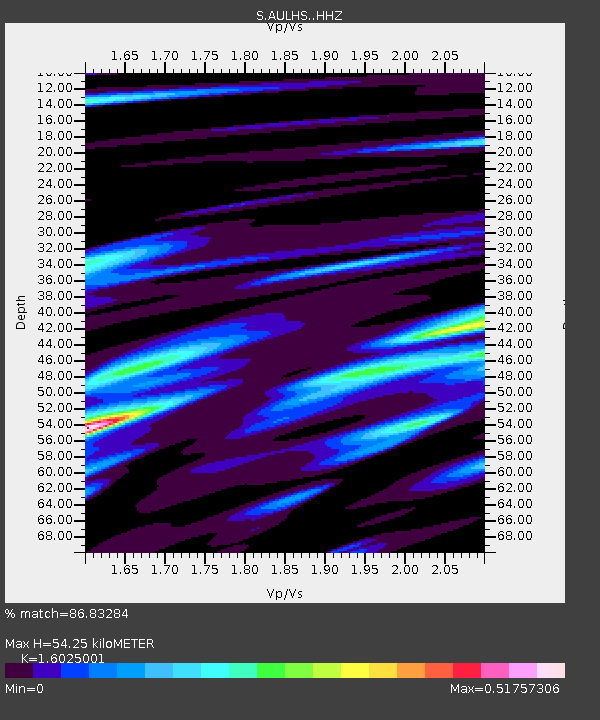
| Estimated Moho Depth: |
54.25 km |
| Estimated Crust Vp/Vs: |
1.60 |
| Assumed Crust Vp: |
6.39 km/s |
| Estimated Crust Vs: |
3.988 km/s |
| Estimated Crust Poisson's Ratio: |
0.18 |
|
| Radial Match: |
86.83284 % |
| Radial Bump: |
400 |
| Transverse Match: |
82.181244 % |
| Transverse Bump: |
400 |
| SOD ConfigId: |
11737051 |
| Insert Time: |
2019-04-25 08:51:35.721 +0000 |
| GWidth: |
2.5 |
| Max Bumps: |
400 |
| Tol: |
0.001 |
|

Signal To Noise
| Channel | StoN | STA | LTA |
| S:AULHS: :HHZ:20160824T10:46:17.349976Z | 13.622959 | 7.0835504E-6 | 5.199715E-7 |
| S:AULHS: :HHN:20160824T10:46:17.349976Z | 4.5009665 | 2.0746545E-6 | 4.6093535E-7 |
| S:AULHS: :HHE:20160824T10:46:17.349976Z | 8.843937 | 3.2721239E-6 | 3.6998497E-7 |
| Arrivals |
| Ps | 5.3 SECOND |
| PpPs | 21 SECOND |
| PsPs/PpSs | 27 SECOND |


