You are here: Home > Network List > S - Seismographs in Schools Projects Stations List
> Station AUUHS Ulladulla High School, Ulladulla, NSW > Earthquake Result Viewer
AUUHS Ulladulla High School, Ulladulla, NSW - Earthquake Result Viewer
| Earthquake location: |
Myanmar |
| Earthquake latitude/longitude: |
20.9/94.6 |
| Earthquake time(UTC): |
2016/08/24 (237) 10:34:55 GMT |
| Earthquake Depth: |
84 km |
| Earthquake Magnitude: |
6.8 MO |
| Earthquake Catalog/Contributor: |
NEIC PDE/NEIC ALERT |
|
| Network: |
S Seismographs in Schools Projects |
| Station: |
AUUHS Ulladulla High School, Ulladulla, NSW |
| Lat/Lon: |
35.36 S/150.47 E |
| Elevation: |
44 m |
|
| Distance: |
77.1 deg |
| Az: |
136.02 deg |
| Baz: |
307.417 deg |
| Ray Param: |
0.050396256 |
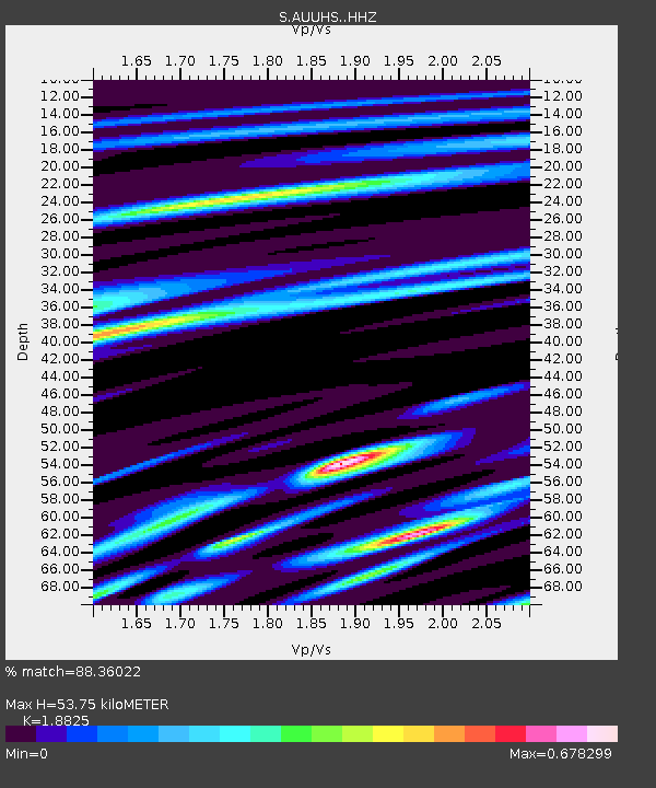
| Estimated Moho Depth: |
53.75 km |
| Estimated Crust Vp/Vs: |
1.88 |
| Assumed Crust Vp: |
6.472 km/s |
| Estimated Crust Vs: |
3.438 km/s |
| Estimated Crust Poisson's Ratio: |
0.30 |
|
| Radial Match: |
88.36022 % |
| Radial Bump: |
400 |
| Transverse Match: |
68.22223 % |
| Transverse Bump: |
400 |
| SOD ConfigId: |
11737051 |
| Insert Time: |
2019-04-25 08:51:47.164 +0000 |
| GWidth: |
2.5 |
| Max Bumps: |
400 |
| Tol: |
0.001 |
|

Signal To Noise
| Channel | StoN | STA | LTA |
| S:AUUHS: :HHZ:20160824T10:46:07.849976Z | 19.089668 | 9.652876E-6 | 5.0565967E-7 |
| S:AUUHS: :HHN:20160824T10:46:07.849976Z | 3.7192743 | 1.6280948E-6 | 4.3774526E-7 |
| S:AUUHS: :HHE:20160824T10:46:07.849976Z | 5.5722404 | 2.5304328E-6 | 4.541141E-7 |
| Arrivals |
| Ps | 7.5 SECOND |
| PpPs | 23 SECOND |
| PsPs/PpSs | 31 SECOND |


