You are here: Home > Network List > TA - USArray Transportable Network (new EarthScope stations) Stations List
> Station G22K Bettles, AK, USA > Earthquake Result Viewer
G22K Bettles, AK, USA - Earthquake Result Viewer
| Earthquake location: |
Myanmar |
| Earthquake latitude/longitude: |
20.9/94.6 |
| Earthquake time(UTC): |
2016/08/24 (237) 10:34:55 GMT |
| Earthquake Depth: |
84 km |
| Earthquake Magnitude: |
6.8 MO |
| Earthquake Catalog/Contributor: |
NEIC PDE/NEIC ALERT |
|
| Network: |
TA USArray Transportable Network (new EarthScope stations) |
| Station: |
G22K Bettles, AK, USA |
| Lat/Lon: |
66.92 N/151.51 W |
| Elevation: |
205 m |
|
| Distance: |
79.8 deg |
| Az: |
21.479 deg |
| Baz: |
299.737 deg |
| Ray Param: |
0.048522618 |
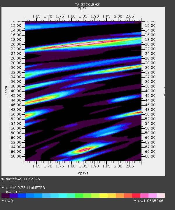
| Estimated Moho Depth: |
19.75 km |
| Estimated Crust Vp/Vs: |
1.84 |
| Assumed Crust Vp: |
6.577 km/s |
| Estimated Crust Vs: |
3.584 km/s |
| Estimated Crust Poisson's Ratio: |
0.29 |
|
| Radial Match: |
90.062325 % |
| Radial Bump: |
400 |
| Transverse Match: |
93.554695 % |
| Transverse Bump: |
372 |
| SOD ConfigId: |
11737051 |
| Insert Time: |
2019-04-25 08:52:14.033 +0000 |
| GWidth: |
2.5 |
| Max Bumps: |
400 |
| Tol: |
0.001 |
|

Signal To Noise
| Channel | StoN | STA | LTA |
| TA:G22K: :BHZ:20160824T10:46:22.950012Z | 49.793262 | 5.127832E-6 | 1.0298244E-7 |
| TA:G22K: :BHN:20160824T10:46:22.950012Z | 10.61158 | 1.160391E-6 | 1.0935139E-7 |
| TA:G22K: :BHE:20160824T10:46:22.950012Z | 24.38157 | 2.6450894E-6 | 1.0848724E-7 |
| Arrivals |
| Ps | 2.6 SECOND |
| PpPs | 8.3 SECOND |
| PsPs/PpSs | 11 SECOND |


