You are here: Home > Network List > US - United States National Seismic Network Stations List
> Station TPNV Topopah Spring, Nevada, USA > Earthquake Result Viewer
TPNV Topopah Spring, Nevada, USA - Earthquake Result Viewer
| Earthquake location: |
South Of Panama |
| Earthquake latitude/longitude: |
4.6/-78.5 |
| Earthquake time(UTC): |
2007/03/18 (077) 02:11:05 GMT |
| Earthquake Depth: |
8.0 km |
| Earthquake Magnitude: |
6.4 MB, 5.7 MS, 6.2 MW, 6.1 MW |
| Earthquake Catalog/Contributor: |
WHDF/NEIC |
|
| Network: |
US United States National Seismic Network |
| Station: |
TPNV Topopah Spring, Nevada, USA |
| Lat/Lon: |
36.95 N/116.25 W |
| Elevation: |
1600 m |
|
| Distance: |
47.2 deg |
| Az: |
318.087 deg |
| Baz: |
123.776 deg |
| Ray Param: |
0.0701294 |
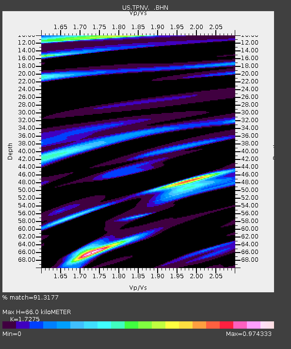
| Estimated Moho Depth: |
66.0 km |
| Estimated Crust Vp/Vs: |
1.73 |
| Assumed Crust Vp: |
6.279 km/s |
| Estimated Crust Vs: |
3.634 km/s |
| Estimated Crust Poisson's Ratio: |
0.25 |
|
| Radial Match: |
91.3177 % |
| Radial Bump: |
400 |
| Transverse Match: |
76.68917 % |
| Transverse Bump: |
400 |
| SOD ConfigId: |
2564 |
| Insert Time: |
2010-03-05 06:27:23.486 +0000 |
| GWidth: |
2.5 |
| Max Bumps: |
400 |
| Tol: |
0.001 |
|

Signal To Noise
| Channel | StoN | STA | LTA |
| US:TPNV: :BHN:20070318T02:19:07.95701Z | 2.3871493 | 3.6419348E-7 | 1.5256418E-7 |
| US:TPNV: :BHE:20070318T02:19:07.95701Z | 4.584256 | 6.1384884E-7 | 1.339037E-7 |
| US:TPNV: :BHZ:20070318T02:19:07.95701Z | 9.901793 | 1.341121E-6 | 1.3544224E-7 |
| Arrivals |
| Ps | 8.1 SECOND |
| PpPs | 27 SECOND |
| PsPs/PpSs | 35 SECOND |


