You are here: Home > Network List > TA - USArray Transportable Network (new EarthScope stations) Stations List
> Station HARP HAARP, Gakona, AK, USA > Earthquake Result Viewer
HARP HAARP, Gakona, AK, USA - Earthquake Result Viewer
| Earthquake location: |
Myanmar |
| Earthquake latitude/longitude: |
20.9/94.6 |
| Earthquake time(UTC): |
2016/08/24 (237) 10:34:55 GMT |
| Earthquake Depth: |
84 km |
| Earthquake Magnitude: |
6.8 MO |
| Earthquake Catalog/Contributor: |
NEIC PDE/NEIC ALERT |
|
| Network: |
TA USArray Transportable Network (new EarthScope stations) |
| Station: |
HARP HAARP, Gakona, AK, USA |
| Lat/Lon: |
62.40 N/145.16 W |
| Elevation: |
581 m |
|
| Distance: |
84.6 deg |
| Az: |
23.835 deg |
| Baz: |
305.796 deg |
| Ray Param: |
0.04521542 |
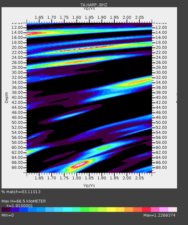
| Estimated Moho Depth: |
66.5 km |
| Estimated Crust Vp/Vs: |
1.81 |
| Assumed Crust Vp: |
6.566 km/s |
| Estimated Crust Vs: |
3.628 km/s |
| Estimated Crust Poisson's Ratio: |
0.28 |
|
| Radial Match: |
83.11013 % |
| Radial Bump: |
400 |
| Transverse Match: |
83.452126 % |
| Transverse Bump: |
400 |
| SOD ConfigId: |
11737051 |
| Insert Time: |
2019-04-25 08:52:23.853 +0000 |
| GWidth: |
2.5 |
| Max Bumps: |
400 |
| Tol: |
0.001 |
|

Signal To Noise
| Channel | StoN | STA | LTA |
| TA:HARP: :BHZ:20160824T10:46:47.650024Z | 45.403915 | 1.2023321E-5 | 2.64808E-7 |
| TA:HARP: :BHN:20160824T10:46:47.650024Z | 9.085232 | 3.0517174E-6 | 3.3589868E-7 |
| TA:HARP: :BHE:20160824T10:46:47.650024Z | 12.554477 | 3.8546955E-6 | 3.0703754E-7 |
| Arrivals |
| Ps | 8.4 SECOND |
| PpPs | 28 SECOND |
| PsPs/PpSs | 36 SECOND |


