You are here: Home > Network List > TA - USArray Transportable Network (new EarthScope stations) Stations List
> Station K29M Barlow Dome, YT, CAN > Earthquake Result Viewer
K29M Barlow Dome, YT, CAN - Earthquake Result Viewer
| Earthquake location: |
Myanmar |
| Earthquake latitude/longitude: |
20.9/94.6 |
| Earthquake time(UTC): |
2016/08/24 (237) 10:34:55 GMT |
| Earthquake Depth: |
84 km |
| Earthquake Magnitude: |
6.8 MO |
| Earthquake Catalog/Contributor: |
NEIC PDE/NEIC ALERT |
|
| Network: |
TA USArray Transportable Network (new EarthScope stations) |
| Station: |
K29M Barlow Dome, YT, CAN |
| Lat/Lon: |
63.84 N/137.52 W |
| Elevation: |
1367 m |
|
| Distance: |
86.4 deg |
| Az: |
20.514 deg |
| Baz: |
312.338 deg |
| Ray Param: |
0.043945767 |
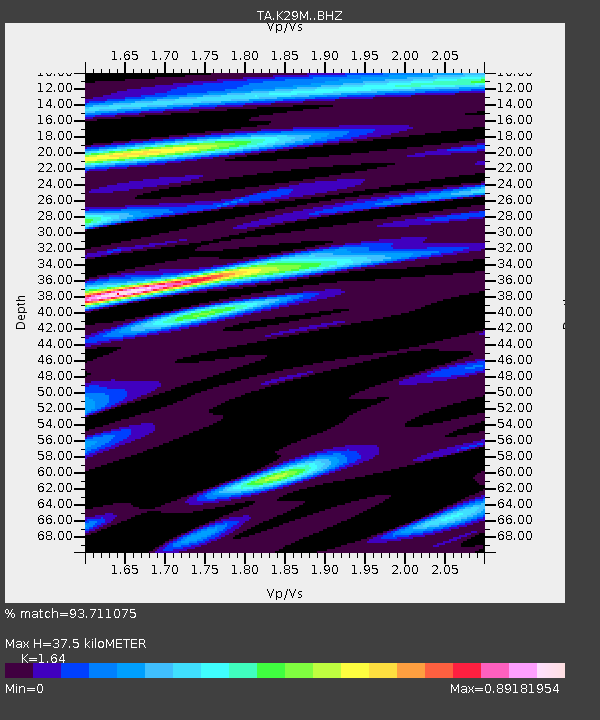
| Estimated Moho Depth: |
37.5 km |
| Estimated Crust Vp/Vs: |
1.64 |
| Assumed Crust Vp: |
6.566 km/s |
| Estimated Crust Vs: |
4.004 km/s |
| Estimated Crust Poisson's Ratio: |
0.20 |
|
| Radial Match: |
93.711075 % |
| Radial Bump: |
400 |
| Transverse Match: |
89.974724 % |
| Transverse Bump: |
400 |
| SOD ConfigId: |
11737051 |
| Insert Time: |
2019-04-25 08:52:34.138 +0000 |
| GWidth: |
2.5 |
| Max Bumps: |
400 |
| Tol: |
0.001 |
|
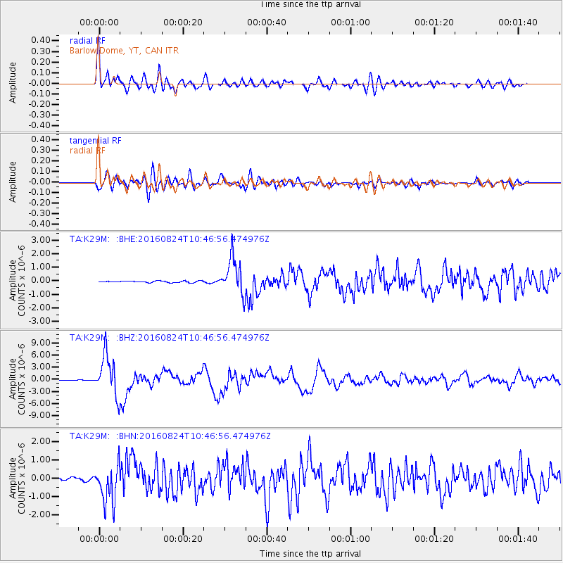
Signal To Noise
| Channel | StoN | STA | LTA |
| TA:K29M: :BHZ:20160824T10:46:56.474976Z | 90.537735 | 5.149093E-6 | 5.687234E-8 |
| TA:K29M: :BHN:20160824T10:46:56.474976Z | 11.74768 | 1.0559603E-6 | 8.9886704E-8 |
| TA:K29M: :BHE:20160824T10:46:56.474976Z | 24.473665 | 1.3905287E-6 | 5.6817345E-8 |
| Arrivals |
| Ps | 3.8 SECOND |
| PpPs | 15 SECOND |
| PsPs/PpSs | 18 SECOND |


