You are here: Home > Network List > TA - USArray Transportable Network (new EarthScope stations) Stations List
> Station M20K Styx River, AK, USA > Earthquake Result Viewer
M20K Styx River, AK, USA - Earthquake Result Viewer
| Earthquake location: |
Myanmar |
| Earthquake latitude/longitude: |
20.9/94.6 |
| Earthquake time(UTC): |
2016/08/24 (237) 10:34:55 GMT |
| Earthquake Depth: |
84 km |
| Earthquake Magnitude: |
6.8 MO |
| Earthquake Catalog/Contributor: |
NEIC PDE/NEIC ALERT |
|
| Network: |
TA USArray Transportable Network (new EarthScope stations) |
| Station: |
M20K Styx River, AK, USA |
| Lat/Lon: |
61.88 N/153.13 W |
| Elevation: |
1107 m |
|
| Distance: |
81.7 deg |
| Az: |
26.296 deg |
| Baz: |
299.048 deg |
| Ray Param: |
0.04723437 |
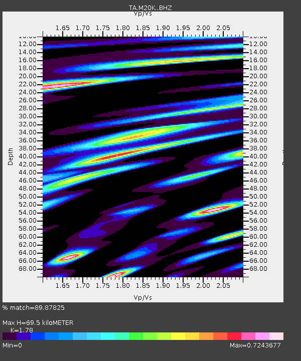
| Estimated Moho Depth: |
69.5 km |
| Estimated Crust Vp/Vs: |
1.78 |
| Assumed Crust Vp: |
6.566 km/s |
| Estimated Crust Vs: |
3.689 km/s |
| Estimated Crust Poisson's Ratio: |
0.27 |
|
| Radial Match: |
89.87825 % |
| Radial Bump: |
400 |
| Transverse Match: |
79.808395 % |
| Transverse Bump: |
400 |
| SOD ConfigId: |
11737051 |
| Insert Time: |
2019-04-25 08:52:40.224 +0000 |
| GWidth: |
2.5 |
| Max Bumps: |
400 |
| Tol: |
0.001 |
|

Signal To Noise
| Channel | StoN | STA | LTA |
| TA:M20K: :BHZ:20160824T10:46:32.875Z | 78.71156 | 7.205037E-6 | 9.153721E-8 |
| TA:M20K: :BHN:20160824T10:46:32.875Z | 15.271663 | 1.4472903E-6 | 9.476965E-8 |
| TA:M20K: :BHE:20160824T10:46:32.875Z | 32.245777 | 2.5116412E-6 | 7.7890554E-8 |
| Arrivals |
| Ps | 8.5 SECOND |
| PpPs | 29 SECOND |
| PsPs/PpSs | 37 SECOND |


