You are here: Home > Network List > TA - USArray Transportable Network (new EarthScope stations) Stations List
> Station O18K Koktuh Hills, AK, USA > Earthquake Result Viewer
O18K Koktuh Hills, AK, USA - Earthquake Result Viewer

| Earthquake location: |
Myanmar |
| Earthquake latitude/longitude: |
20.9/94.6 |
| Earthquake time(UTC): |
2016/08/24 (237) 10:34:55 GMT |
| Earthquake Depth: |
84 km |
| Earthquake Magnitude: |
6.8 MO |
| Earthquake Catalog/Contributor: |
NEIC PDE/NEIC ALERT |
|
| Network: |
TA USArray Transportable Network (new EarthScope stations) |
| Station: |
O18K Koktuh Hills, AK, USA |
| Lat/Lon: |
59.85 N/155.21 W |
| Elevation: |
544 m |
|
| Distance: |
81.8 deg |
| Az: |
28.593 deg |
| Baz: |
297.567 deg |
| Ray Param: |
0.047185004 |
| Estimated Moho Depth: |
33.25 km |
| Estimated Crust Vp/Vs: |
1.87 |
| Assumed Crust Vp: |
6.438 km/s |
| Estimated Crust Vs: |
3.448 km/s |
| Estimated Crust Poisson's Ratio: |
0.30 |
|
| Radial Match: |
96.13335 % |
| Radial Bump: |
392 |
| Transverse Match: |
89.368546 % |
| Transverse Bump: |
400 |
| SOD ConfigId: |
11737051 |
| Insert Time: |
2019-04-25 08:52:56.281 +0000 |
| GWidth: |
2.5 |
| Max Bumps: |
400 |
| Tol: |
0.001 |
|
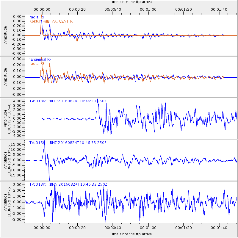
Signal To Noise
| Channel | StoN | STA | LTA |
| TA:O18K: :BHZ:20160824T10:46:33.250Z | 54.004147 | 8.433348E-6 | 1.5616111E-7 |
| TA:O18K: :BHN:20160824T10:46:33.250Z | 5.1075196 | 8.81567E-7 | 1.7260179E-7 |
| TA:O18K: :BHE:20160824T10:46:33.250Z | 19.73358 | 1.9596273E-6 | 9.93042E-8 |
| Arrivals |
| Ps | 4.6 SECOND |
| PpPs | 14 SECOND |
| PsPs/PpSs | 19 SECOND |


