You are here: Home > Network List > TA - USArray Transportable Network (new EarthScope stations) Stations List
> Station V35K Ketchikan, AK, USA > Earthquake Result Viewer
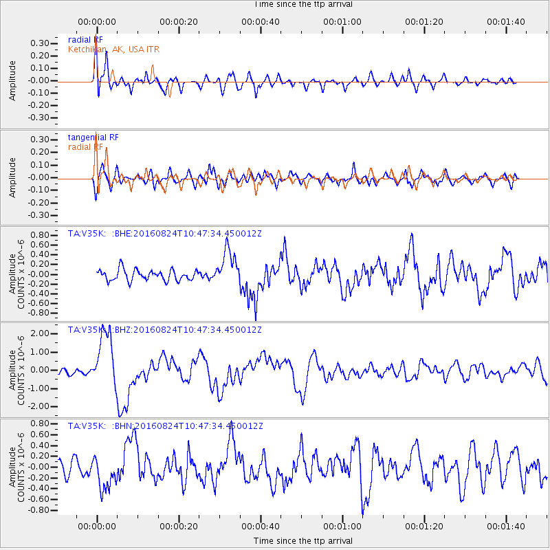
V35K Ketchikan, AK, USA - Earthquake Result Viewer
*The percent match for this event was below the threshold and hence no stack was calculated.
| Earthquake location: |
Myanmar |
| Earthquake latitude/longitude: |
20.9/94.6 |
| Earthquake time(UTC): |
2016/08/24 (237) 10:34:55 GMT |
| Earthquake Depth: |
84 km |
| Earthquake Magnitude: |
6.8 MO |
| Earthquake Catalog/Contributor: |
NEIC PDE/NEIC ALERT |
|
| Network: |
TA USArray Transportable Network (new EarthScope stations) |
| Station: |
V35K Ketchikan, AK, USA |
| Lat/Lon: |
55.33 N/131.62 W |
| Elevation: |
64 m |
|
| Distance: |
94.5 deg |
| Az: |
24.437 deg |
| Baz: |
317.407 deg |
| Ray Param: |
$rayparam |
*The percent match for this event was below the threshold and hence was not used in the summary stack. |
|
| Radial Match: |
68.779274 % |
| Radial Bump: |
400 |
| Transverse Match: |
73.551674 % |
| Transverse Bump: |
400 |
| SOD ConfigId: |
11737051 |
| Insert Time: |
2019-04-25 08:53:19.325 +0000 |
| GWidth: |
2.5 |
| Max Bumps: |
400 |
| Tol: |
0.001 |
|
Signal To Noise
| Channel | StoN | STA | LTA |
| TA:V35K: :BHZ:20160824T10:47:34.450012Z | 14.225272 | 1.6060172E-6 | 1.12898874E-7 |
| TA:V35K: :BHN:20160824T10:47:34.450012Z | 1.6979823 | 3.194658E-7 | 1.8814437E-7 |
| TA:V35K: :BHE:20160824T10:47:34.450012Z | 3.3703423 | 3.7218427E-7 | 1.1042921E-7 |
| Arrivals |
| Ps | |
| PpPs | |
| PsPs/PpSs | |


