You are here: Home > Network List > US - United States National Seismic Network Stations List
> Station TPNV Topopah Spring, Nevada, USA > Earthquake Result Viewer
TPNV Topopah Spring, Nevada, USA - Earthquake Result Viewer
| Earthquake location: |
South Of Panama |
| Earthquake latitude/longitude: |
7.9/-82.8 |
| Earthquake time(UTC): |
2002/07/31 (212) 00:16:44 GMT |
| Earthquake Depth: |
10 km |
| Earthquake Magnitude: |
6.0 MB, 6.4 MS, 6.5 MW, 6.4 MW |
| Earthquake Catalog/Contributor: |
WHDF/NEIC |
|
| Network: |
US United States National Seismic Network |
| Station: |
TPNV Topopah Spring, Nevada, USA |
| Lat/Lon: |
36.95 N/116.25 W |
| Elevation: |
1600 m |
|
| Distance: |
41.9 deg |
| Az: |
318.618 deg |
| Baz: |
125.174 deg |
| Ray Param: |
0.073485866 |
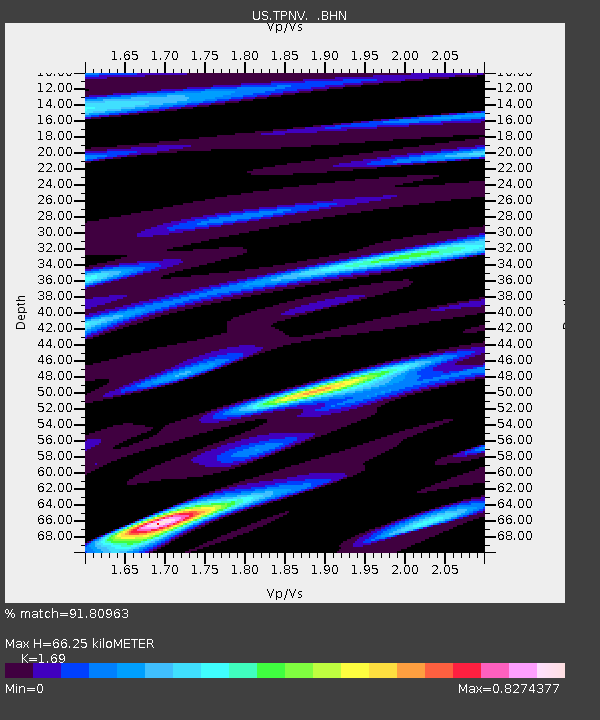
| Estimated Moho Depth: |
66.25 km |
| Estimated Crust Vp/Vs: |
1.69 |
| Assumed Crust Vp: |
6.279 km/s |
| Estimated Crust Vs: |
3.715 km/s |
| Estimated Crust Poisson's Ratio: |
0.23 |
|
| Radial Match: |
91.80963 % |
| Radial Bump: |
400 |
| Transverse Match: |
90.7425 % |
| Transverse Bump: |
400 |
| SOD ConfigId: |
110165 |
| Insert Time: |
2010-03-05 06:27:51.842 +0000 |
| GWidth: |
2.5 |
| Max Bumps: |
400 |
| Tol: |
0.001 |
|

Signal To Noise
| Channel | StoN | STA | LTA |
| US:TPNV: :BHN:20020731T00:24:04.366012Z | 1.0223297 | 8.199401E-8 | 8.02031E-8 |
| US:TPNV: :BHE:20020731T00:24:04.366012Z | 0.8671439 | 7.992126E-8 | 9.216608E-8 |
| US:TPNV: :BHZ:20020731T00:24:04.366012Z | 1.5185133 | 2.2384997E-7 | 1.474139E-7 |
| Arrivals |
| Ps | 7.8 SECOND |
| PpPs | 27 SECOND |
| PsPs/PpSs | 34 SECOND |


