You are here: Home > Network List > US - United States National Seismic Network Stations List
> Station TPNV Topopah Spring, Nevada, USA > Earthquake Result Viewer
TPNV Topopah Spring, Nevada, USA - Earthquake Result Viewer
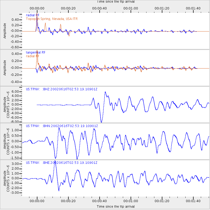
| Earthquake location: |
Costa Rica |
| Earthquake latitude/longitude: |
8.8/-84.0 |
| Earthquake time(UTC): |
2002/06/16 (167) 02:46:14 GMT |
| Earthquake Depth: |
35 km |
| Earthquake Magnitude: |
5.4 MB, 6.2 MS, 6.4 MW, 6.4 MW |
| Earthquake Catalog/Contributor: |
WHDF/NEIC |
|
| Network: |
US United States National Seismic Network |
| Station: |
TPNV Topopah Spring, Nevada, USA |
| Lat/Lon: |
36.95 N/116.25 W |
| Elevation: |
1600 m |
|
| Distance: |
40.5 deg |
| Az: |
318.824 deg |
| Baz: |
125.676 deg |
| Ray Param: |
0.07429694 |
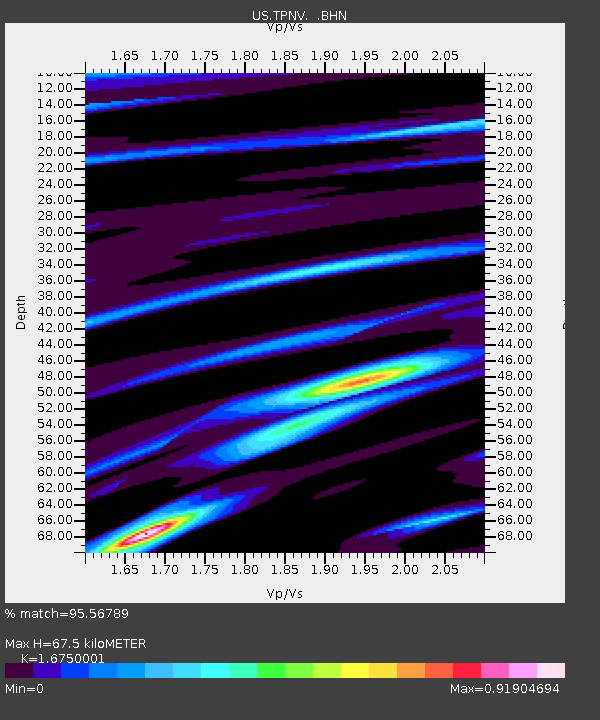
| Estimated Moho Depth: |
67.5 km |
| Estimated Crust Vp/Vs: |
1.68 |
| Assumed Crust Vp: |
6.279 km/s |
| Estimated Crust Vs: |
3.748 km/s |
| Estimated Crust Poisson's Ratio: |
0.22 |
|
| Radial Match: |
95.56789 % |
| Radial Bump: |
329 |
| Transverse Match: |
90.3476 % |
| Transverse Bump: |
400 |
| SOD ConfigId: |
110165 |
| Insert Time: |
2010-03-05 06:27:53.747 +0000 |
| GWidth: |
2.5 |
| Max Bumps: |
400 |
| Tol: |
0.001 |
|
Signal To Noise
| Channel | StoN | STA | LTA |
| US:TPNV: :BHN:20020616T02:53:19.10901Z | 1.0934356 | 5.99569E-8 | 5.4833496E-8 |
| US:TPNV: :BHE:20020616T02:53:19.10901Z | 1.1428963 | 8.269823E-8 | 7.2358475E-8 |
| US:TPNV: :BHZ:20020616T02:53:19.10901Z | 1.2440482 | 1.063387E-7 | 8.5477964E-8 |
| Arrivals |
| Ps | 7.8 SECOND |
| PpPs | 27 SECOND |
| PsPs/PpSs | 35 SECOND |


