You are here: Home > Network List > US - United States National Seismic Network Stations List
> Station TPNV Topopah Spring, Nevada, USA > Earthquake Result Viewer
TPNV Topopah Spring, Nevada, USA - Earthquake Result Viewer

| Earthquake location: |
Vanuatu Islands |
| Earthquake latitude/longitude: |
-14.4/167.7 |
| Earthquake time(UTC): |
2002/04/11 (101) 21:56:56 GMT |
| Earthquake Depth: |
10 km |
| Earthquake Magnitude: |
5.9 MB, 6.2 MS, 6.2 MW, 6.1 MW |
| Earthquake Catalog/Contributor: |
WHDF/NEIC |
|
| Network: |
US United States National Seismic Network |
| Station: |
TPNV Topopah Spring, Nevada, USA |
| Lat/Lon: |
36.95 N/116.25 W |
| Elevation: |
1600 m |
|
| Distance: |
87.8 deg |
| Az: |
51.089 deg |
| Baz: |
250.256 deg |
| Ray Param: |
0.043092716 |
| Estimated Moho Depth: |
63.25 km |
| Estimated Crust Vp/Vs: |
1.85 |
| Assumed Crust Vp: |
6.279 km/s |
| Estimated Crust Vs: |
3.403 km/s |
| Estimated Crust Poisson's Ratio: |
0.29 |
|
| Radial Match: |
91.62955 % |
| Radial Bump: |
400 |
| Transverse Match: |
79.97615 % |
| Transverse Bump: |
400 |
| SOD ConfigId: |
110177 |
| Insert Time: |
2010-03-05 06:28:01.931 +0000 |
| GWidth: |
2.5 |
| Max Bumps: |
400 |
| Tol: |
0.001 |
|
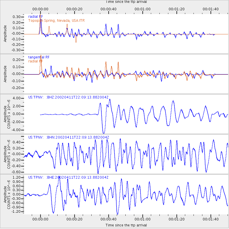
Signal To Noise
| Channel | StoN | STA | LTA |
| US:TPNV: :BHN:20020411T22:09:13.882004Z | 1.2556355 | 6.97458E-8 | 5.5546217E-8 |
| US:TPNV: :BHE:20020411T22:09:13.882004Z | 2.2043998 | 1.1429357E-7 | 5.1847927E-8 |
| US:TPNV: :BHZ:20020411T22:09:13.882004Z | 8.173486 | 6.194342E-7 | 7.5785806E-8 |
| Arrivals |
| Ps | 8.7 SECOND |
| PpPs | 28 SECOND |
| PsPs/PpSs | 37 SECOND |


