You are here: Home > Network List > US - United States National Seismic Network Stations List
> Station TPNV Topopah Spring, Nevada, USA > Earthquake Result Viewer
TPNV Topopah Spring, Nevada, USA - Earthquake Result Viewer
| Earthquake location: |
Near Coast Of Central Chile |
| Earthquake latitude/longitude: |
-30.8/-71.1 |
| Earthquake time(UTC): |
2002/06/18 (169) 13:56:22 GMT |
| Earthquake Depth: |
54 km |
| Earthquake Magnitude: |
6.0 MB, 6.6 MW, 6.4 MW |
| Earthquake Catalog/Contributor: |
WHDF/NEIC |
|
| Network: |
US United States National Seismic Network |
| Station: |
TPNV Topopah Spring, Nevada, USA |
| Lat/Lon: |
36.95 N/116.25 W |
| Elevation: |
1600 m |
|
| Distance: |
79.6 deg |
| Az: |
324.741 deg |
| Baz: |
141.682 deg |
| Ray Param: |
0.048782215 |
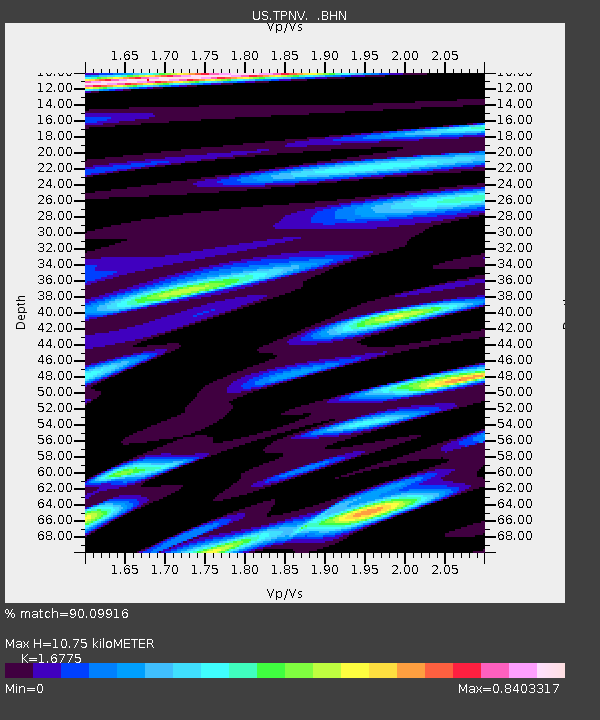
| Estimated Moho Depth: |
10.75 km |
| Estimated Crust Vp/Vs: |
1.68 |
| Assumed Crust Vp: |
6.279 km/s |
| Estimated Crust Vs: |
3.743 km/s |
| Estimated Crust Poisson's Ratio: |
0.22 |
|
| Radial Match: |
90.09916 % |
| Radial Bump: |
400 |
| Transverse Match: |
87.43281 % |
| Transverse Bump: |
400 |
| SOD ConfigId: |
110177 |
| Insert Time: |
2010-03-05 06:28:09.970 +0000 |
| GWidth: |
2.5 |
| Max Bumps: |
400 |
| Tol: |
0.001 |
|
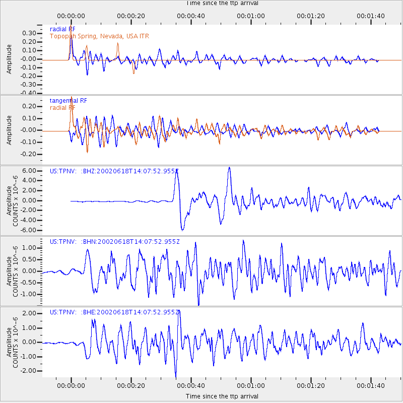
Signal To Noise
| Channel | StoN | STA | LTA |
| US:TPNV: :BHN:20020618T14:07:52.955Z | 3.5777495 | 1.2712795E-7 | 3.553294E-8 |
| US:TPNV: :BHE:20020618T14:07:52.955Z | 3.6888084 | 1.6432578E-7 | 4.4547118E-8 |
| US:TPNV: :BHZ:20020618T14:07:52.955Z | 18.624783 | 1.1695847E-6 | 6.279723E-8 |
| Arrivals |
| Ps | 1.2 SECOND |
| PpPs | 4.5 SECOND |
| PsPs/PpSs | 5.6 SECOND |


