You are here: Home > Network List > TJ - Tajikistan National Seismic Network Stations List
> Station MANEM Manem, Tajikistan > Earthquake Result Viewer
MANEM Manem, Tajikistan - Earthquake Result Viewer
| Earthquake location: |
Southern Sumatra, Indonesia |
| Earthquake latitude/longitude: |
-3.0/100.1 |
| Earthquake time(UTC): |
2016/08/24 (237) 13:48:44 GMT |
| Earthquake Depth: |
17 km |
| Earthquake Magnitude: |
5.8 MB |
| Earthquake Catalog/Contributor: |
NEIC PDE/NEIC COMCAT |
|
| Network: |
TJ Tajikistan National Seismic Network |
| Station: |
MANEM Manem, Tajikistan |
| Lat/Lon: |
37.53 N/71.66 E |
| Elevation: |
2312 m |
|
| Distance: |
48.1 deg |
| Az: |
329.493 deg |
| Baz: |
140.379 deg |
| Ray Param: |
0.06953346 |
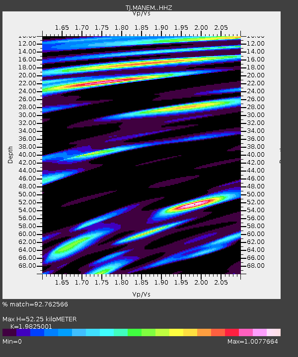
| Estimated Moho Depth: |
52.25 km |
| Estimated Crust Vp/Vs: |
1.98 |
| Assumed Crust Vp: |
6.306 km/s |
| Estimated Crust Vs: |
3.181 km/s |
| Estimated Crust Poisson's Ratio: |
0.33 |
|
| Radial Match: |
92.762566 % |
| Radial Bump: |
400 |
| Transverse Match: |
84.6582 % |
| Transverse Bump: |
400 |
| SOD ConfigId: |
11737051 |
| Insert Time: |
2019-04-25 08:57:00.545 +0000 |
| GWidth: |
2.5 |
| Max Bumps: |
400 |
| Tol: |
0.001 |
|

Signal To Noise
| Channel | StoN | STA | LTA |
| TJ:MANEM: :HHZ:20160824T13:56:52.429988Z | 13.847515 | 2.4951867E-6 | 1.8019021E-7 |
| TJ:MANEM: :HHN:20160824T13:56:52.429988Z | 5.981278 | 8.704664E-7 | 1.4553184E-7 |
| TJ:MANEM: :HHE:20160824T13:56:52.429988Z | 4.863433 | 8.032975E-7 | 1.6517089E-7 |
| Arrivals |
| Ps | 8.6 SECOND |
| PpPs | 23 SECOND |
| PsPs/PpSs | 32 SECOND |


