You are here: Home > Network List > CI - Caltech Regional Seismic Network Stations List
> Station MLAC Mammoth Lakes, California, USA > Earthquake Result Viewer
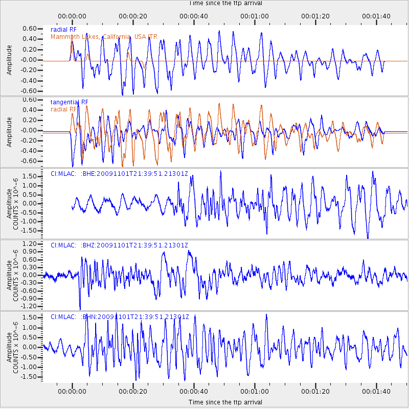
MLAC Mammoth Lakes, California, USA - Earthquake Result Viewer
*The percent match for this event was below the threshold and hence no stack was calculated.
| Earthquake location: |
Tonga Islands |
| Earthquake latitude/longitude: |
-15.5/-173.8 |
| Earthquake time(UTC): |
2009/11/01 (305) 21:28:58 GMT |
| Earthquake Depth: |
105 km |
| Earthquake Magnitude: |
5.8 MW, 5.4 MB, 5.8 MW |
| Earthquake Catalog/Contributor: |
WHDF/NEIC |
|
| Network: |
CI Caltech Regional Seismic Network |
| Station: |
MLAC Mammoth Lakes, California, USA |
| Lat/Lon: |
37.63 N/118.84 W |
| Elevation: |
2134 m |
|
| Distance: |
73.8 deg |
| Az: |
42.567 deg |
| Baz: |
235.224 deg |
| Ray Param: |
$rayparam |
*The percent match for this event was below the threshold and hence was not used in the summary stack. |
|
| Radial Match: |
65.57228 % |
| Radial Bump: |
400 |
| Transverse Match: |
59.43628 % |
| Transverse Bump: |
400 |
| SOD ConfigId: |
2622 |
| Insert Time: |
2010-02-26 00:41:08.568 +0000 |
| GWidth: |
2.5 |
| Max Bumps: |
400 |
| Tol: |
0.001 |
|
Signal To Noise
| Channel | StoN | STA | LTA |
| CI:MLAC: :BHZ:20091101T21:39:51.21301Z | 2.9789371 | 4.2436056E-7 | 1.4245369E-7 |
| CI:MLAC: :BHN:20091101T21:39:51.21301Z | 2.7355933 | 5.471875E-7 | 2.0002514E-7 |
| CI:MLAC: :BHE:20091101T21:39:51.21301Z | 1.2668782 | 3.4954485E-7 | 2.7591037E-7 |
| Arrivals |
| Ps | |
| PpPs | |
| PsPs/PpSs | |


