You are here: Home > Network List > US - United States National Seismic Network Stations List
> Station TPNV Topopah Spring, Nevada, USA > Earthquake Result Viewer
TPNV Topopah Spring, Nevada, USA - Earthquake Result Viewer
| Earthquake location: |
Near Coast Of Central Chile |
| Earthquake latitude/longitude: |
-30.6/-71.6 |
| Earthquake time(UTC): |
2003/06/20 (171) 13:30:41 GMT |
| Earthquake Depth: |
33 km |
| Earthquake Magnitude: |
6.4 MB, 6.8 MS, 6.8 MW, 6.7 MW |
| Earthquake Catalog/Contributor: |
WHDF/NEIC |
|
| Network: |
US United States National Seismic Network |
| Station: |
TPNV Topopah Spring, Nevada, USA |
| Lat/Lon: |
36.95 N/116.25 W |
| Elevation: |
1600 m |
|
| Distance: |
79.1 deg |
| Az: |
325.048 deg |
| Baz: |
141.935 deg |
| Ray Param: |
0.049121063 |
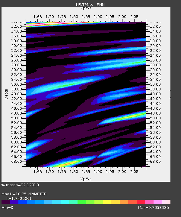
| Estimated Moho Depth: |
10.25 km |
| Estimated Crust Vp/Vs: |
1.74 |
| Assumed Crust Vp: |
6.279 km/s |
| Estimated Crust Vs: |
3.603 km/s |
| Estimated Crust Poisson's Ratio: |
0.25 |
|
| Radial Match: |
92.17919 % |
| Radial Bump: |
400 |
| Transverse Match: |
91.74042 % |
| Transverse Bump: |
387 |
| SOD ConfigId: |
110177 |
| Insert Time: |
2010-03-05 06:28:41.117 +0000 |
| GWidth: |
2.5 |
| Max Bumps: |
400 |
| Tol: |
0.001 |
|

Signal To Noise
| Channel | StoN | STA | LTA |
| US:TPNV: :BHN:20030620T13:42:11.877Z | 1.4657742 | 9.999296E-8 | 6.821853E-8 |
| US:TPNV: :BHE:20030620T13:42:11.877Z | 1.1890727 | 7.932934E-8 | 6.67153E-8 |
| US:TPNV: :BHZ:20030620T13:42:11.877Z | 6.6319866 | 4.7387323E-7 | 7.145268E-8 |
| Arrivals |
| Ps | 1.2 SECOND |
| PpPs | 4.4 SECOND |
| PsPs/PpSs | 5.6 SECOND |


