You are here: Home > Network List > US - United States National Seismic Network Stations List
> Station TPNV Topopah Spring, Nevada, USA > Earthquake Result Viewer
TPNV Topopah Spring, Nevada, USA - Earthquake Result Viewer
| Earthquake location: |
Eastern Honshu, Japan |
| Earthquake latitude/longitude: |
38.4/141.0 |
| Earthquake time(UTC): |
2003/07/25 (206) 22:13:29 GMT |
| Earthquake Depth: |
6.0 km |
| Earthquake Magnitude: |
6.0 MB, 5.8 MS, 6.1 MW, 5.9 MW |
| Earthquake Catalog/Contributor: |
WHDF/NEIC |
|
| Network: |
US United States National Seismic Network |
| Station: |
TPNV Topopah Spring, Nevada, USA |
| Lat/Lon: |
36.95 N/116.25 W |
| Elevation: |
1600 m |
|
| Distance: |
76.6 deg |
| Az: |
53.431 deg |
| Baz: |
308.043 deg |
| Ray Param: |
0.05088005 |
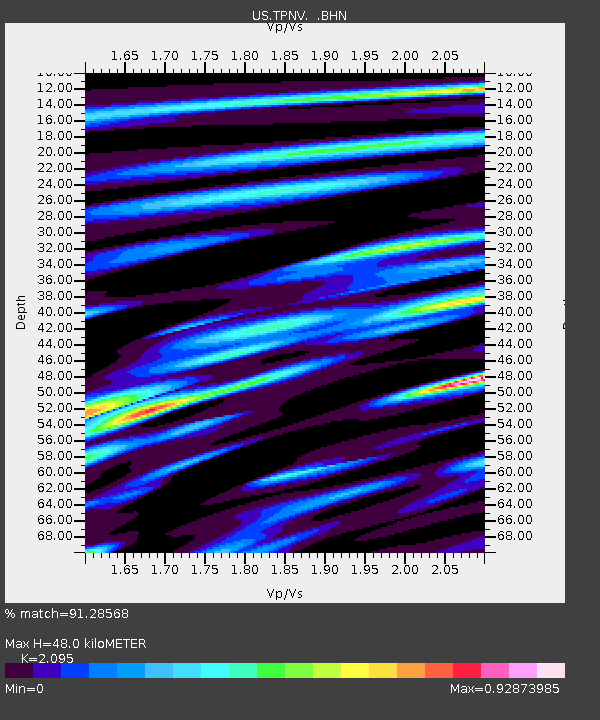
| Estimated Moho Depth: |
48.0 km |
| Estimated Crust Vp/Vs: |
2.10 |
| Assumed Crust Vp: |
6.279 km/s |
| Estimated Crust Vs: |
2.997 km/s |
| Estimated Crust Poisson's Ratio: |
0.35 |
|
| Radial Match: |
91.28568 % |
| Radial Bump: |
400 |
| Transverse Match: |
83.74855 % |
| Transverse Bump: |
400 |
| SOD ConfigId: |
110177 |
| Insert Time: |
2010-03-05 06:28:46.763 +0000 |
| GWidth: |
2.5 |
| Max Bumps: |
400 |
| Tol: |
0.001 |
|
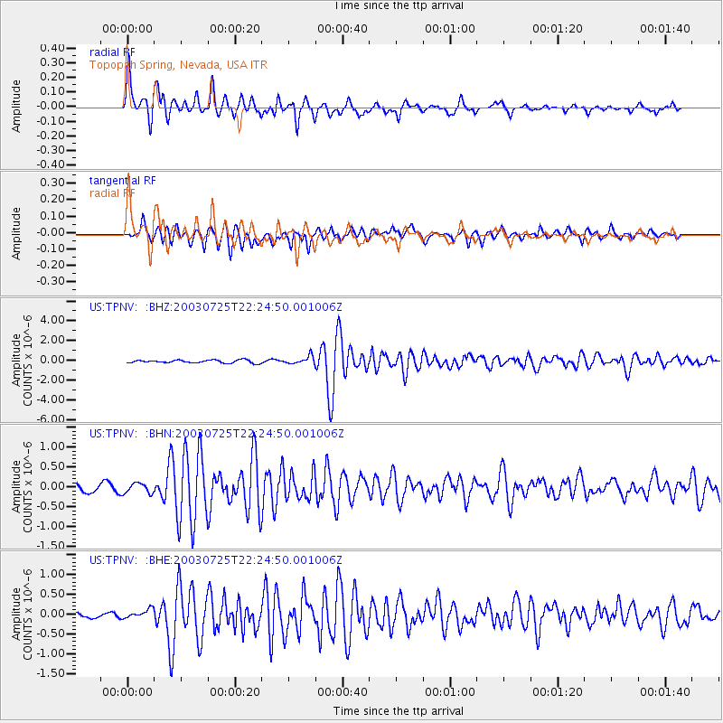
Signal To Noise
| Channel | StoN | STA | LTA |
| US:TPNV: :BHN:20030725T22:24:50.001006Z | 1.0164855 | 1.2687701E-7 | 1.2481931E-7 |
| US:TPNV: :BHE:20030725T22:24:50.001006Z | 1.49839 | 1.12833504E-7 | 7.530316E-8 |
| US:TPNV: :BHZ:20030725T22:24:50.001006Z | 2.6404383 | 3.9873592E-7 | 1.5101126E-7 |
| Arrivals |
| Ps | 8.6 SECOND |
| PpPs | 23 SECOND |
| PsPs/PpSs | 32 SECOND |


