You are here: Home > Network List > US - United States National Seismic Network Stations List
> Station TPNV Topopah Spring, Nevada, USA > Earthquake Result Viewer
TPNV Topopah Spring, Nevada, USA - Earthquake Result Viewer
| Earthquake location: |
Fiji Islands Region |
| Earthquake latitude/longitude: |
-21.1/-176.6 |
| Earthquake time(UTC): |
2003/07/27 (208) 02:04:11 GMT |
| Earthquake Depth: |
213 km |
| Earthquake Magnitude: |
5.9 MB, 6.6 MW, 6.6 MW |
| Earthquake Catalog/Contributor: |
WHDF/NEIC |
|
| Network: |
US United States National Seismic Network |
| Station: |
TPNV Topopah Spring, Nevada, USA |
| Lat/Lon: |
36.95 N/116.25 W |
| Elevation: |
1600 m |
|
| Distance: |
81.0 deg |
| Az: |
44.811 deg |
| Baz: |
235.243 deg |
| Ray Param: |
0.0473494 |
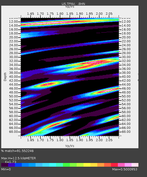
| Estimated Moho Depth: |
12.5 km |
| Estimated Crust Vp/Vs: |
1.73 |
| Assumed Crust Vp: |
6.279 km/s |
| Estimated Crust Vs: |
3.629 km/s |
| Estimated Crust Poisson's Ratio: |
0.25 |
|
| Radial Match: |
91.552246 % |
| Radial Bump: |
400 |
| Transverse Match: |
80.208206 % |
| Transverse Bump: |
400 |
| SOD ConfigId: |
110177 |
| Insert Time: |
2010-03-05 06:28:48.231 +0000 |
| GWidth: |
2.5 |
| Max Bumps: |
400 |
| Tol: |
0.001 |
|

Signal To Noise
| Channel | StoN | STA | LTA |
| US:TPNV: :BHN:20030727T02:15:31.246003Z | 2.9211051 | 2.1681048E-7 | 7.422207E-8 |
| US:TPNV: :BHE:20030727T02:15:31.246003Z | 5.2059665 | 2.9037471E-7 | 5.5777292E-8 |
| US:TPNV: :BHZ:20030727T02:15:31.246003Z | 14.227925 | 1.3106247E-6 | 9.211636E-8 |
| Arrivals |
| Ps | 1.5 SECOND |
| PpPs | 5.3 SECOND |
| PsPs/PpSs | 6.8 SECOND |


