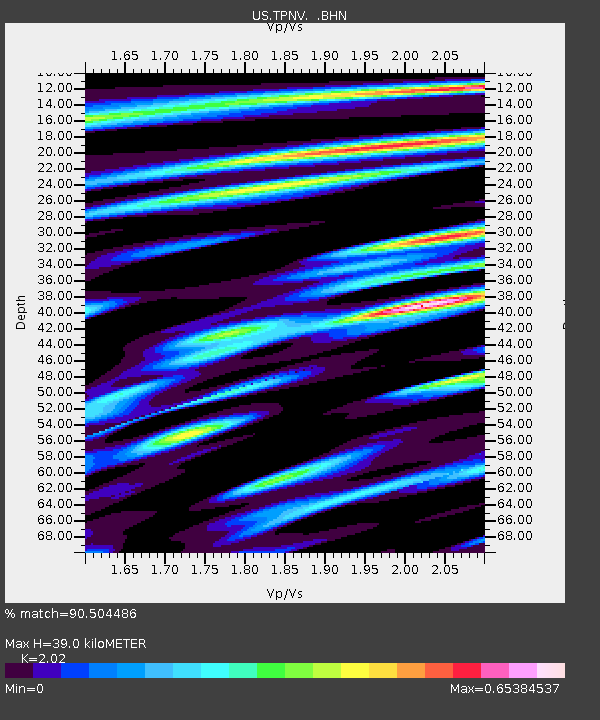
TPNV Topopah Spring, Nevada, USA - Earthquake Result Viewer
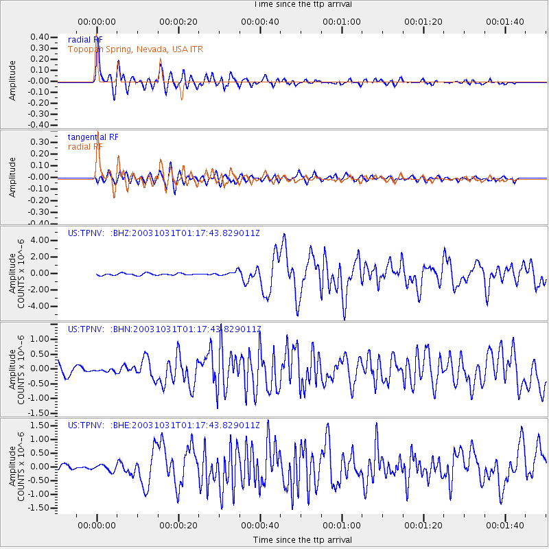
Earthquake location: Off East Coast Of Honshu, Japan
Earthquake latitude/longitude: 37.8/142.6
Earthquake time(UTC): 2003/10/31 (304) 01:06:28 GMT
Earthquake Depth: 10 km
Earthquake Magnitude: 6.1 MB, 6.8 MS, 7.0 MW, 7.0 MW
Earthquake Catalog/Contributor: WHDF/NEIC
Network: US United States National Seismic Network
Station: TPNV Topopah Spring, Nevada, USA
Lat/Lon: 36.95 N/116.25 W
Elevation: 1600 m
Distance: 75.9 deg
Az: 54.126 deg
Baz: 306.764 deg
Ray Param: 0.05132846
Estimated Moho Depth: 39.0 km
Estimated Crust Vp/Vs: 2.02
Assumed Crust Vp: 6.279 km/s
Estimated Crust Vs: 3.108 km/s
Estimated Crust Poisson's Ratio: 0.34
Radial Match: 90.504486 %
Radial Bump: 400
Transverse Match: 78.797554 %
Transverse Bump: 400
SOD ConfigId: 110177
Insert Time: 2010-03-05 06:28:56.341 +0000
GWidth: 2.5
Max Bumps: 400
Tol: 0.001

Signal To Noise

ChannelStoNSTALTA
US:TPNV: :BHN:20031031T01:17:43.829011Z0.27536344.4802075E-81.6270165E-7
US:TPNV: :BHE:20031031T01:17:43.829011Z1.125151.113173E-79.8935516E-8
US:TPNV: :BHZ:20031031T01:17:43.829011Z2.43779042.8707544E-71.17760514E-7
Arrivals
Ps6.5 SECOND
PpPs18 SECOND
PsPs/PpSs25 SECOND