You are here: Home > Network List > US - United States National Seismic Network Stations List
> Station TPNV Topopah Spring, Nevada, USA > Earthquake Result Viewer
TPNV Topopah Spring, Nevada, USA - Earthquake Result Viewer

| Earthquake location: |
Komandorskiye Ostrova Region |
| Earthquake latitude/longitude: |
55.5/165.8 |
| Earthquake time(UTC): |
2003/12/05 (339) 21:26:09 GMT |
| Earthquake Depth: |
10 km |
| Earthquake Magnitude: |
6.1 MB, 6.5 MS, 6.7 MW, 6.7 MW |
| Earthquake Catalog/Contributor: |
WHDF/NEIC |
|
| Network: |
US United States National Seismic Network |
| Station: |
TPNV Topopah Spring, Nevada, USA |
| Lat/Lon: |
36.95 N/116.25 W |
| Elevation: |
1600 m |
|
| Distance: |
54.0 deg |
| Az: |
75.484 deg |
| Baz: |
316.613 deg |
| Ray Param: |
0.06570138 |
| Estimated Moho Depth: |
54.5 km |
| Estimated Crust Vp/Vs: |
1.61 |
| Assumed Crust Vp: |
6.279 km/s |
| Estimated Crust Vs: |
3.912 km/s |
| Estimated Crust Poisson's Ratio: |
0.18 |
|
| Radial Match: |
93.42018 % |
| Radial Bump: |
400 |
| Transverse Match: |
78.04648 % |
| Transverse Bump: |
400 |
| SOD ConfigId: |
110177 |
| Insert Time: |
2010-03-05 06:29:02.194 +0000 |
| GWidth: |
2.5 |
| Max Bumps: |
400 |
| Tol: |
0.001 |
|
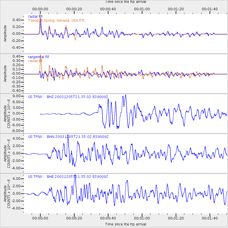
Signal To Noise
| Channel | StoN | STA | LTA |
| US:TPNV: :BHN:20031205T21:35:02.839009Z | 0.86156327 | 2.7350455E-7 | 3.174515E-7 |
| US:TPNV: :BHE:20031205T21:35:02.839009Z | 0.95888287 | 3.5434797E-7 | 3.695425E-7 |
| US:TPNV: :BHZ:20031205T21:35:02.839009Z | 8.100167 | 1.4982231E-6 | 1.8496199E-7 |
| Arrivals |
| Ps | 5.6 SECOND |
| PpPs | 21 SECOND |
| PsPs/PpSs | 27 SECOND |


