You are here: Home > Network List > US - United States National Seismic Network Stations List
> Station TPNV Topopah Spring, Nevada, USA > Earthquake Result Viewer
TPNV Topopah Spring, Nevada, USA - Earthquake Result Viewer

| Earthquake location: |
Hokkaido, Japan Region |
| Earthquake latitude/longitude: |
42.5/144.4 |
| Earthquake time(UTC): |
2003/09/29 (272) 02:36:53 GMT |
| Earthquake Depth: |
25 km |
| Earthquake Magnitude: |
6.1 MB, 6.3 MS, 6.5 MW, 6.4 MW |
| Earthquake Catalog/Contributor: |
WHDF/NEIC |
|
| Network: |
US United States National Seismic Network |
| Station: |
TPNV Topopah Spring, Nevada, USA |
| Lat/Lon: |
36.95 N/116.25 W |
| Elevation: |
1600 m |
|
| Distance: |
72.2 deg |
| Az: |
56.122 deg |
| Baz: |
309.912 deg |
| Ray Param: |
0.05379822 |
| Estimated Moho Depth: |
11.75 km |
| Estimated Crust Vp/Vs: |
2.09 |
| Assumed Crust Vp: |
6.279 km/s |
| Estimated Crust Vs: |
3.011 km/s |
| Estimated Crust Poisson's Ratio: |
0.35 |
|
| Radial Match: |
90.576836 % |
| Radial Bump: |
400 |
| Transverse Match: |
81.87662 % |
| Transverse Bump: |
400 |
| SOD ConfigId: |
110165 |
| Insert Time: |
2010-03-05 06:29:10.113 +0000 |
| GWidth: |
2.5 |
| Max Bumps: |
400 |
| Tol: |
0.001 |
|
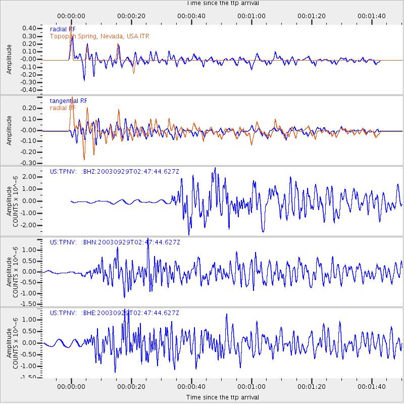
Signal To Noise
| Channel | StoN | STA | LTA |
| US:TPNV: :BHN:20030929T02:47:44.627Z | 0.7411264 | 7.5519466E-8 | 1.0189822E-7 |
| US:TPNV: :BHE:20030929T02:47:44.627Z | 1.5927844 | 1.1406819E-7 | 7.161559E-8 |
| US:TPNV: :BHZ:20030929T02:47:44.627Z | 1.988257 | 1.8392166E-7 | 9.250396E-8 |
| Arrivals |
| Ps | 2.1 SECOND |
| PpPs | 5.6 SECOND |
| PsPs/PpSs | 7.7 SECOND |


