You are here: Home > Network List > US - United States National Seismic Network Stations List
> Station TPNV Topopah Spring, Nevada, USA > Earthquake Result Viewer
TPNV Topopah Spring, Nevada, USA - Earthquake Result Viewer
| Earthquake location: |
Hokkaido, Japan Region |
| Earthquake latitude/longitude: |
41.8/143.9 |
| Earthquake time(UTC): |
2003/09/25 (268) 19:50:06 GMT |
| Earthquake Depth: |
27 km |
| Earthquake Magnitude: |
6.9 MB, 8.1 MS, 8.3 MW, 8.1 MW |
| Earthquake Catalog/Contributor: |
WHDF/NEIC |
|
| Network: |
US United States National Seismic Network |
| Station: |
TPNV Topopah Spring, Nevada, USA |
| Lat/Lon: |
36.95 N/116.25 W |
| Elevation: |
1600 m |
|
| Distance: |
72.8 deg |
| Az: |
55.704 deg |
| Baz: |
309.567 deg |
| Ray Param: |
0.05336872 |
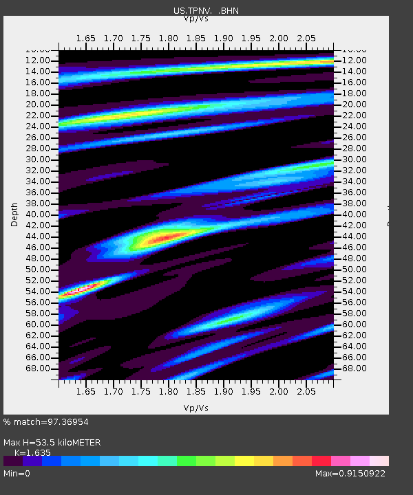
| Estimated Moho Depth: |
53.5 km |
| Estimated Crust Vp/Vs: |
1.63 |
| Assumed Crust Vp: |
6.279 km/s |
| Estimated Crust Vs: |
3.84 km/s |
| Estimated Crust Poisson's Ratio: |
0.20 |
|
| Radial Match: |
97.36954 % |
| Radial Bump: |
400 |
| Transverse Match: |
91.408005 % |
| Transverse Bump: |
400 |
| SOD ConfigId: |
110165 |
| Insert Time: |
2010-03-05 06:29:14.308 +0000 |
| GWidth: |
2.5 |
| Max Bumps: |
400 |
| Tol: |
0.001 |
|
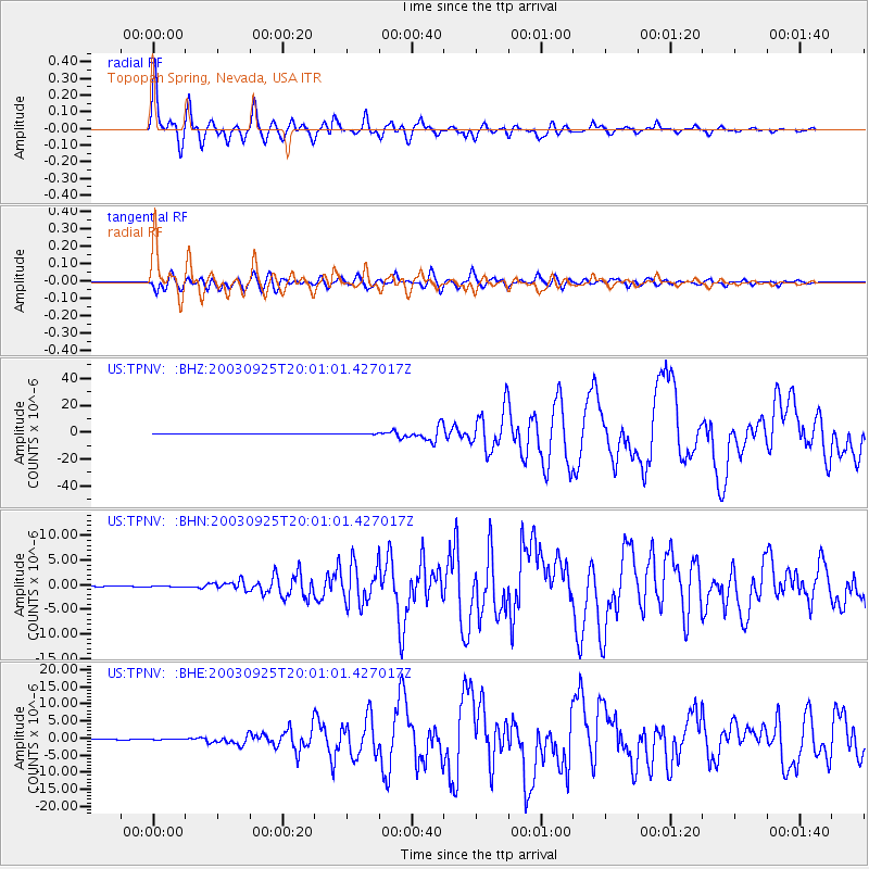
Signal To Noise
| Channel | StoN | STA | LTA |
| US:TPNV: :BHN:20030925T20:01:01.427017Z | 1.5596209 | 1.0333079E-7 | 6.625379E-8 |
| US:TPNV: :BHE:20030925T20:01:01.427017Z | 0.74449176 | 6.2354914E-8 | 8.375501E-8 |
| US:TPNV: :BHZ:20030925T20:01:01.427017Z | 2.3666685 | 2.5158295E-7 | 1.06302565E-7 |
| Arrivals |
| Ps | 5.6 SECOND |
| PpPs | 22 SECOND |
| PsPs/PpSs | 27 SECOND |


