You are here: Home > Network List > US - United States National Seismic Network Stations List
> Station TPNV Topopah Spring, Nevada, USA > Earthquake Result Viewer
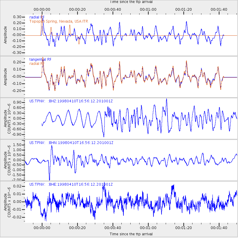
TPNV Topopah Spring, Nevada, USA - Earthquake Result Viewer
*The percent match for this event was below the threshold and hence no stack was calculated.
| Earthquake location: |
South Of Kermadec Islands |
| Earthquake latitude/longitude: |
-33.5/-179.5 |
| Earthquake time(UTC): |
1998/04/10 (100) 16:43:41 GMT |
| Earthquake Depth: |
46 km |
| Earthquake Magnitude: |
5.9 MB, 5.9 MS, 6.0 UNKNOWN, 6.0 MW |
| Earthquake Catalog/Contributor: |
WHDF/NEIC |
|
| Network: |
US United States National Seismic Network |
| Station: |
TPNV Topopah Spring, Nevada, USA |
| Lat/Lon: |
36.95 N/116.25 W |
| Elevation: |
1600 m |
|
| Distance: |
91.6 deg |
| Az: |
45.72 deg |
| Baz: |
228.276 deg |
| Ray Param: |
$rayparam |
*The percent match for this event was below the threshold and hence was not used in the summary stack. |
|
| Radial Match: |
62.7608 % |
| Radial Bump: |
400 |
| Transverse Match: |
62.75172 % |
| Transverse Bump: |
400 |
| SOD ConfigId: |
4480 |
| Insert Time: |
2010-03-05 06:29:37.349 +0000 |
| GWidth: |
2.5 |
| Max Bumps: |
400 |
| Tol: |
0.001 |
|
Signal To Noise
| Channel | StoN | STA | LTA |
| US:TPNV: :BHN:19980410T16:56:12.201001Z | 2.3720844 | 5.709447E-7 | 2.4069325E-7 |
| US:TPNV: :BHE:19980410T16:56:12.201001Z | 1.8043648 | 1.45753845E-8 | 8.077848E-9 |
| US:TPNV: :BHZ:19980410T16:56:12.201001Z | 1.4365528 | 3.882787E-7 | 2.7028503E-7 |
| Arrivals |
| Ps | |
| PpPs | |
| PsPs/PpSs | |


