You are here: Home > Network List > GS - US Geological Survey Networks Stations List
> Station DEC09 Decatur Surface Seismic Site, Decatur, IL, USA > Earthquake Result Viewer
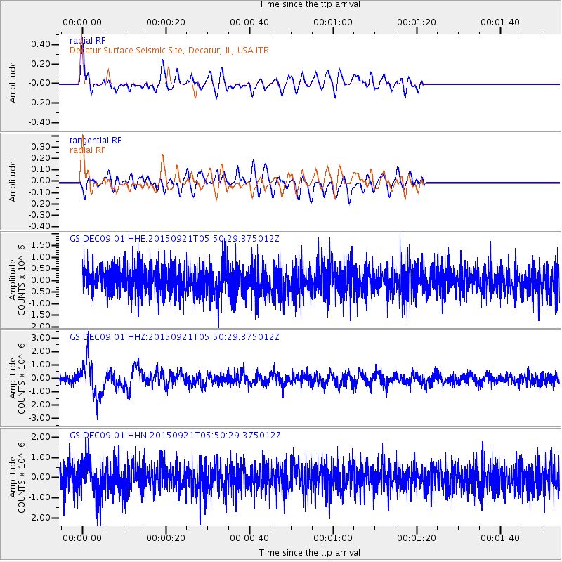
DEC09 Decatur Surface Seismic Site, Decatur, IL, USA - Earthquake Result Viewer
*The percent match for this event was below the threshold and hence no stack was calculated.
| Earthquake location: |
Near Coast Of Central Chile |
| Earthquake latitude/longitude: |
-31.6/-71.7 |
| Earthquake time(UTC): |
2015/09/21 (264) 05:39:33 GMT |
| Earthquake Depth: |
23 km |
| Earthquake Magnitude: |
6.3 MWP |
| Earthquake Catalog/Contributor: |
NEIC PDE/NEIC COMCAT |
|
| Network: |
GS US Geological Survey Networks |
| Station: |
DEC09 Decatur Surface Seismic Site, Decatur, IL, USA |
| Lat/Lon: |
39.87 N/88.92 W |
| Elevation: |
207 m |
|
| Distance: |
72.9 deg |
| Az: |
346.214 deg |
| Baz: |
164.677 deg |
| Ray Param: |
$rayparam |
*The percent match for this event was below the threshold and hence was not used in the summary stack. |
|
| Radial Match: |
70.75418 % |
| Radial Bump: |
400 |
| Transverse Match: |
52.748318 % |
| Transverse Bump: |
400 |
| SOD ConfigId: |
1156111 |
| Insert Time: |
2015-10-05 06:24:39.651 +0000 |
| GWidth: |
2.5 |
| Max Bumps: |
400 |
| Tol: |
0.001 |
|
Signal To Noise
| Channel | StoN | STA | LTA |
| GS:DEC09:01:HHZ:20150921T05:50:29.375012Z | 4.629678 | 1.3157597E-6 | 2.8420115E-7 |
| GS:DEC09:01:HHN:20150921T05:50:29.375012Z | 1.4766189 | 8.497834E-7 | 5.754927E-7 |
| GS:DEC09:01:HHE:20150921T05:50:29.375012Z | 1.2879243 | 7.3656946E-7 | 5.719043E-7 |
| Arrivals |
| Ps | |
| PpPs | |
| PsPs/PpSs | |


