You are here: Home > Network List > TA - USArray Transportable Network (new EarthScope stations) Stations List
> Station D23K Nanushuk River, AK USA > Earthquake Result Viewer
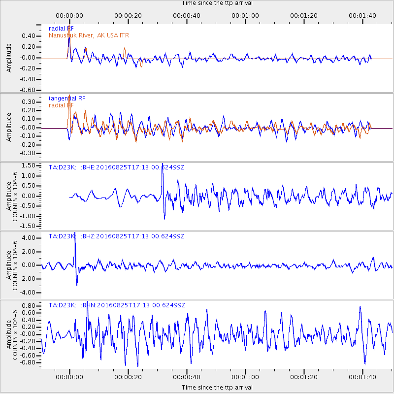
D23K Nanushuk River, AK USA - Earthquake Result Viewer
*The percent match for this event was below the threshold and hence no stack was calculated.
| Earthquake location: |
Southeast Of Honshu, Japan |
| Earthquake latitude/longitude: |
30.6/137.8 |
| Earthquake time(UTC): |
2016/08/25 (238) 17:04:43 GMT |
| Earthquake Depth: |
456 km |
| Earthquake Magnitude: |
5.9 MWW, 5.9 MWB |
| Earthquake Catalog/Contributor: |
NEIC PDE/NEIC COMCAT |
|
| Network: |
TA USArray Transportable Network (new EarthScope stations) |
| Station: |
D23K Nanushuk River, AK USA |
| Lat/Lon: |
68.97 N/150.68 W |
| Elevation: |
406 m |
|
| Distance: |
55.1 deg |
| Az: |
24.654 deg |
| Baz: |
264.931 deg |
| Ray Param: |
$rayparam |
*The percent match for this event was below the threshold and hence was not used in the summary stack. |
|
| Radial Match: |
65.52012 % |
| Radial Bump: |
400 |
| Transverse Match: |
49.4527 % |
| Transverse Bump: |
327 |
| SOD ConfigId: |
11737051 |
| Insert Time: |
2019-04-25 09:05:12.405 +0000 |
| GWidth: |
2.5 |
| Max Bumps: |
400 |
| Tol: |
0.001 |
|
Signal To Noise
| Channel | StoN | STA | LTA |
| TA:D23K: :BHZ:20160825T17:13:00.62499Z | 5.72465 | 1.4403372E-6 | 2.5160267E-7 |
| TA:D23K: :BHN:20160825T17:13:00.62499Z | 0.88230276 | 2.1960491E-7 | 2.488997E-7 |
| TA:D23K: :BHE:20160825T17:13:00.62499Z | 2.8117254 | 5.1787777E-7 | 1.8418504E-7 |
| Arrivals |
| Ps | |
| PpPs | |
| PsPs/PpSs | |


