You are here: Home > Network List > TA - USArray Transportable Network (new EarthScope stations) Stations List
> Station H17A Grant Village (NPS), Yellowstone Nt. Park, WY, USA > Earthquake Result Viewer
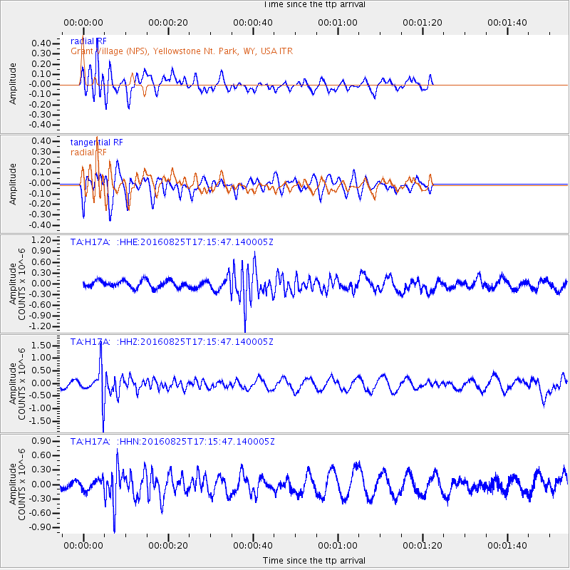
H17A Grant Village (NPS), Yellowstone Nt. Park, WY, USA - Earthquake Result Viewer
*The percent match for this event was below the threshold and hence no stack was calculated.
| Earthquake location: |
Southeast Of Honshu, Japan |
| Earthquake latitude/longitude: |
30.6/137.8 |
| Earthquake time(UTC): |
2016/08/25 (238) 17:04:43 GMT |
| Earthquake Depth: |
456 km |
| Earthquake Magnitude: |
5.9 MWW, 5.9 MWB |
| Earthquake Catalog/Contributor: |
NEIC PDE/NEIC COMCAT |
|
| Network: |
TA USArray Transportable Network (new EarthScope stations) |
| Station: |
H17A Grant Village (NPS), Yellowstone Nt. Park, WY, USA |
| Lat/Lon: |
44.40 N/110.58 W |
| Elevation: |
2400 m |
|
| Distance: |
82.8 deg |
| Az: |
42.221 deg |
| Baz: |
306.087 deg |
| Ray Param: |
$rayparam |
*The percent match for this event was below the threshold and hence was not used in the summary stack. |
|
| Radial Match: |
68.6603 % |
| Radial Bump: |
400 |
| Transverse Match: |
75.064064 % |
| Transverse Bump: |
398 |
| SOD ConfigId: |
11737051 |
| Insert Time: |
2019-04-25 09:05:33.976 +0000 |
| GWidth: |
2.5 |
| Max Bumps: |
400 |
| Tol: |
0.001 |
|
Signal To Noise
| Channel | StoN | STA | LTA |
| TA:H17A: :HHZ:20160825T17:15:47.140005Z | 4.6092143 | 6.126342E-7 | 1.329151E-7 |
| TA:H17A: :HHN:20160825T17:15:47.140005Z | 0.99470854 | 1.0804567E-7 | 1.08620426E-7 |
| TA:H17A: :HHE:20160825T17:15:47.140005Z | 1.8101646 | 1.80378E-7 | 9.964729E-8 |
| Arrivals |
| Ps | |
| PpPs | |
| PsPs/PpSs | |


