You are here: Home > Network List > TA - USArray Transportable Network (new EarthScope stations) Stations List
> Station H22K Ishtalitna Creek, AK, USA > Earthquake Result Viewer
H22K Ishtalitna Creek, AK, USA - Earthquake Result Viewer
| Earthquake location: |
Southeast Of Honshu, Japan |
| Earthquake latitude/longitude: |
30.6/137.8 |
| Earthquake time(UTC): |
2016/08/25 (238) 17:04:43 GMT |
| Earthquake Depth: |
456 km |
| Earthquake Magnitude: |
5.9 MWW, 5.9 MWB |
| Earthquake Catalog/Contributor: |
NEIC PDE/NEIC COMCAT |
|
| Network: |
TA USArray Transportable Network (new EarthScope stations) |
| Station: |
H22K Ishtalitna Creek, AK, USA |
| Lat/Lon: |
65.89 N/151.38 W |
| Elevation: |
561 m |
|
| Distance: |
54.6 deg |
| Az: |
28.392 deg |
| Baz: |
266.438 deg |
| Ray Param: |
0.06348232 |
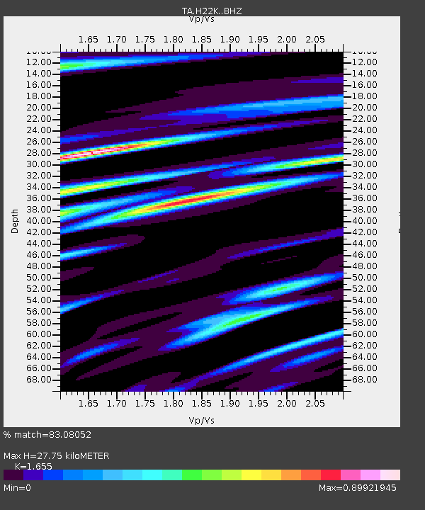
| Estimated Moho Depth: |
27.75 km |
| Estimated Crust Vp/Vs: |
1.65 |
| Assumed Crust Vp: |
6.566 km/s |
| Estimated Crust Vs: |
3.967 km/s |
| Estimated Crust Poisson's Ratio: |
0.21 |
|
| Radial Match: |
83.08052 % |
| Radial Bump: |
400 |
| Transverse Match: |
69.92859 % |
| Transverse Bump: |
400 |
| SOD ConfigId: |
11737051 |
| Insert Time: |
2019-04-25 09:05:35.888 +0000 |
| GWidth: |
2.5 |
| Max Bumps: |
400 |
| Tol: |
0.001 |
|

Signal To Noise
| Channel | StoN | STA | LTA |
| TA:H22K: :BHZ:20160825T17:12:57.099996Z | 16.138693 | 1.2823697E-6 | 7.945932E-8 |
| TA:H22K: :BHN:20160825T17:12:57.099996Z | 1.76113 | 1.4371993E-7 | 8.160666E-8 |
| TA:H22K: :BHE:20160825T17:12:57.099996Z | 8.181223 | 5.9804194E-7 | 7.309933E-8 |
| Arrivals |
| Ps | 2.9 SECOND |
| PpPs | 11 SECOND |
| PsPs/PpSs | 14 SECOND |


