You are here: Home > Network List > TA - USArray Transportable Network (new EarthScope stations) Stations List
> Station J26L Joseph Creek, AK, USA > Earthquake Result Viewer
J26L Joseph Creek, AK, USA - Earthquake Result Viewer
*The percent match for this event was below the threshold and hence no stack was calculated.
| Earthquake location: |
Southeast Of Honshu, Japan |
| Earthquake latitude/longitude: |
30.6/137.8 |
| Earthquake time(UTC): |
2016/08/25 (238) 17:04:43 GMT |
| Earthquake Depth: |
456 km |
| Earthquake Magnitude: |
5.9 MWW, 5.9 MWB |
| Earthquake Catalog/Contributor: |
NEIC PDE/NEIC COMCAT |
|
| Network: |
TA USArray Transportable Network (new EarthScope stations) |
| Station: |
J26L Joseph Creek, AK, USA |
| Lat/Lon: |
64.50 N/143.56 W |
| Elevation: |
1144 m |
|
| Distance: |
58.0 deg |
| Az: |
30.039 deg |
| Baz: |
274.439 deg |
| Ray Param: |
$rayparam |
*The percent match for this event was below the threshold and hence was not used in the summary stack. |
|
| Radial Match: |
71.54612 % |
| Radial Bump: |
400 |
| Transverse Match: |
60.584816 % |
| Transverse Bump: |
400 |
| SOD ConfigId: |
11737051 |
| Insert Time: |
2019-04-25 09:05:49.117 +0000 |
| GWidth: |
2.5 |
| Max Bumps: |
400 |
| Tol: |
0.001 |
|
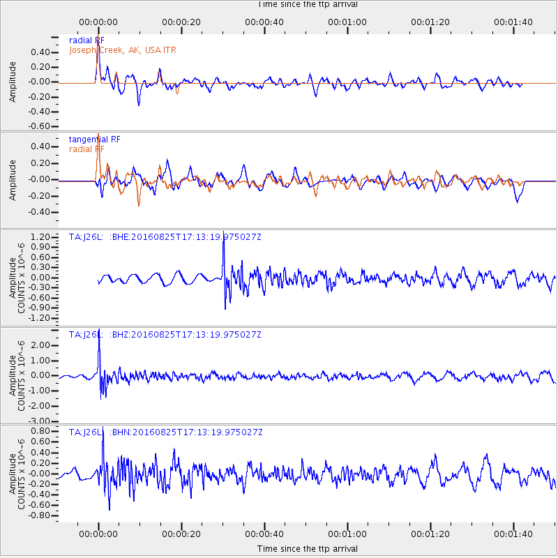
Signal To Noise
| Channel | StoN | STA | LTA |
| TA:J26L: :BHZ:20160825T17:13:19.975027Z | 7.4648585 | 8.3677037E-7 | 1.12094604E-7 |
| TA:J26L: :BHN:20160825T17:13:19.975027Z | 2.544942 | 2.8382522E-7 | 1.1152522E-7 |
| TA:J26L: :BHE:20160825T17:13:19.975027Z | 3.6091943 | 4.198323E-7 | 1.16323E-7 |
| Arrivals |
| Ps | |
| PpPs | |
| PsPs/PpSs | |


