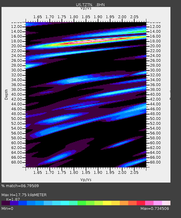
TZTN Tazewell, Tennessee, USA - Earthquake Result Viewer

Earthquake location: Near West Coast Of Honshu, Japan
Earthquake latitude/longitude: 37.5/138.4
Earthquake time(UTC): 2007/07/16 (197) 01:13:22 GMT
Earthquake Depth: 12 km
Earthquake Magnitude: 6.5 MB, 6.4 MS, 6.6 MW, 6.5 MW
Earthquake Catalog/Contributor: WHDF/NEIC
Network: US United States National Seismic Network
Station: TZTN Tazewell, Tennessee, USA
Lat/Lon: 36.54 N/83.55 W
Elevation: 394 m
Distance: 96.7 deg
Az: 32.852 deg
Baz: 327.622 deg
Ray Param: 0.04044516
Estimated Moho Depth: 17.75 km
Estimated Crust Vp/Vs: 1.87
Assumed Crust Vp: 6.476 km/s
Estimated Crust Vs: 3.463 km/s
Estimated Crust Poisson's Ratio: 0.30
Radial Match: 86.79589 %
Radial Bump: 400
Transverse Match: 72.1324 %
Transverse Bump: 400
SOD ConfigId: 2564
Insert Time: 2010-03-05 06:29:54.345 +0000
GWidth: 2.5
Max Bumps: 400
Tol: 0.001

Signal To Noise

ChannelStoNSTALTA
US:TZTN: :BHN:20070716T01:26:20.554021Z2.96408751.6775715E-75.659656E-8
US:TZTN: :BHE:20070716T01:26:20.554021Z2.25311571.4120953E-76.2673E-8
US:TZTN: :BHZ:20070716T01:26:20.554021Z9.1474927.3760816E-78.063501E-8
Arrivals
Ps2.4 SECOND
PpPs7.7 SECOND
PsPs/PpSs10 SECOND