TZTN Tazewell, Tennessee, USA - Earthquake Result Viewer
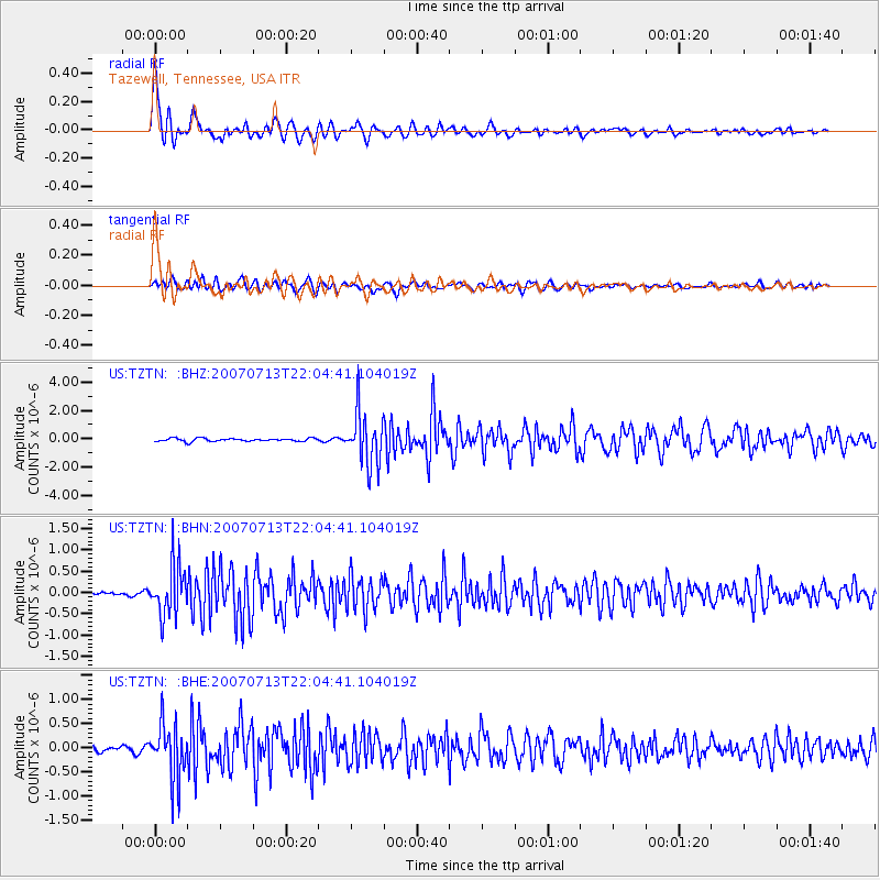
Earthquake location: Andreanof Islands, Aleutian Is.
Earthquake latitude/longitude: 51.8/-176.3
Earthquake time(UTC): 2007/07/13 (194) 21:54:43 GMT
Earthquake Depth: 35 km
Earthquake Magnitude: 5.7 MB, 5.6 MS, 6.0 MW, 5.9 MW
Earthquake Catalog/Contributor: WHDF/NEIC
Network: US United States National Seismic Network
Station: TZTN Tazewell, Tennessee, USA
Lat/Lon: 36.54 N/83.55 W
Elevation: 394 m
Distance: 63.8 deg
Az: 63.679 deg
Baz: 316.325 deg
Ray Param: 0.059265736
Estimated Moho Depth: 43.75 km
Estimated Crust Vp/Vs: 1.84
Assumed Crust Vp: 6.476 km/s
Estimated Crust Vs: 3.524 km/s
Estimated Crust Poisson's Ratio: 0.29
Radial Match: 88.91893 %
Radial Bump: 400
Transverse Match: 77.31168 %
Transverse Bump: 400
SOD ConfigId: 2564
Insert Time: 2010-03-05 06:29:57.732 +0000
GWidth: 2.5
Max Bumps: 400
Tol: 0.001

Signal To Noise

ChannelStoNSTALTA
US:TZTN: :BHN:20070713T22:04:41.104019Z13.1202675.85858E-74.46529E-8
US:TZTN: :BHE:20070713T22:04:41.104019Z11.7039265.711289E-74.8798064E-8
US:TZTN: :BHZ:20070713T22:04:41.104019Z17.1244071.8539996E-61.082665E-7
Arrivals
Ps5.9 SECOND
PpPs18 SECOND
PsPs/PpSs24 SECOND