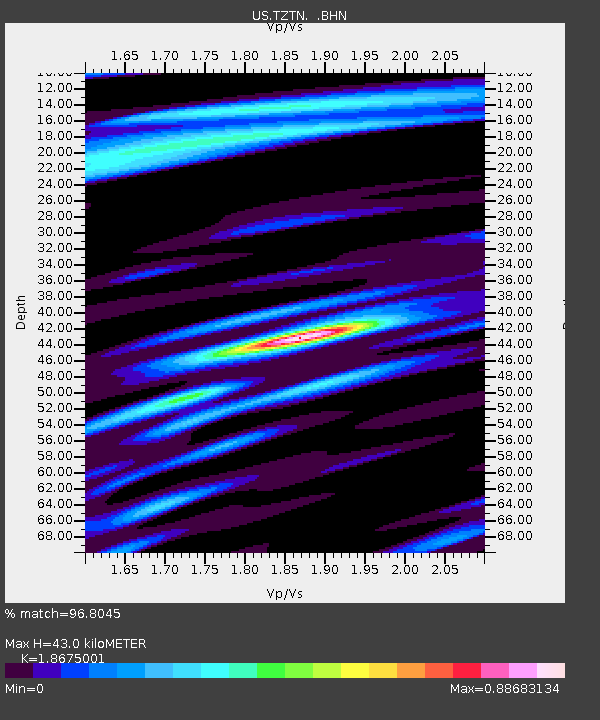
TZTN Tazewell, Tennessee, USA - Earthquake Result Viewer

Earthquake location: Andreanof Islands, Aleutian Is.
Earthquake latitude/longitude: 51.9/-177.5
Earthquake time(UTC): 2008/05/02 (123) 01:33:37 GMT
Earthquake Depth: 14 km
Earthquake Magnitude: 6.3 MB, 6.8 MS, 6.6 MW, 6.6 MW
Earthquake Catalog/Contributor: WHDF/NEIC
Network: US United States National Seismic Network
Station: TZTN Tazewell, Tennessee, USA
Lat/Lon: 36.54 N/83.55 W
Elevation: 394 m
Distance: 64.5 deg
Az: 62.879 deg
Baz: 316.737 deg
Ray Param: 0.05887178
Estimated Moho Depth: 43.0 km
Estimated Crust Vp/Vs: 1.87
Assumed Crust Vp: 6.476 km/s
Estimated Crust Vs: 3.468 km/s
Estimated Crust Poisson's Ratio: 0.30
Radial Match: 96.8045 %
Radial Bump: 400
Transverse Match: 88.45419 %
Transverse Bump: 400
SOD ConfigId: 2504
Insert Time: 2010-03-05 06:30:03.694 +0000
GWidth: 2.5
Max Bumps: 400
Tol: 0.001

Signal To Noise

ChannelStoNSTALTA
US:TZTN: :BHN:20080502T01:43:42.266001Z18.7991541.4721822E-67.831109E-8
US:TZTN: :BHE:20080502T01:43:42.266001Z6.67613033.68412E-75.5183463E-8
US:TZTN: :BHZ:20080502T01:43:42.266001Z3.61263871.6317487E-74.516778E-8
Arrivals
Ps6.0 SECOND
PpPs18 SECOND
PsPs/PpSs24 SECOND