You are here: Home > Network List > GS - US Geological Survey Networks Stations List
> Station KAN13 Rinehart Farm, , CA, USA > Earthquake Result Viewer
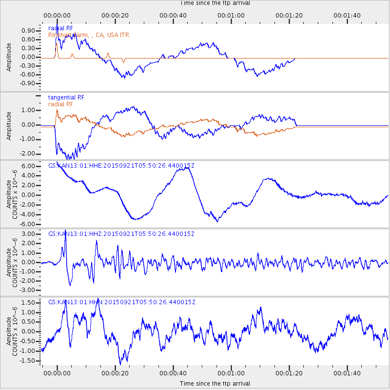
KAN13 Rinehart Farm, , CA, USA - Earthquake Result Viewer
*The percent match for this event was below the threshold and hence no stack was calculated.
| Earthquake location: |
Near Coast Of Central Chile |
| Earthquake latitude/longitude: |
-31.6/-71.7 |
| Earthquake time(UTC): |
2015/09/21 (264) 05:39:33 GMT |
| Earthquake Depth: |
23 km |
| Earthquake Magnitude: |
6.3 MWP |
| Earthquake Catalog/Contributor: |
NEIC PDE/NEIC COMCAT |
|
| Network: |
GS US Geological Survey Networks |
| Station: |
KAN13 Rinehart Farm, , CA, USA |
| Lat/Lon: |
37.01 N/97.48 W |
| Elevation: |
340 m |
|
| Distance: |
72.4 deg |
| Az: |
338.587 deg |
| Baz: |
157.092 deg |
| Ray Param: |
$rayparam |
*The percent match for this event was below the threshold and hence was not used in the summary stack. |
|
| Radial Match: |
59.066826 % |
| Radial Bump: |
400 |
| Transverse Match: |
48.12345 % |
| Transverse Bump: |
400 |
| SOD ConfigId: |
1156111 |
| Insert Time: |
2015-10-05 06:25:29.264 +0000 |
| GWidth: |
2.5 |
| Max Bumps: |
400 |
| Tol: |
0.001 |
|
Signal To Noise
| Channel | StoN | STA | LTA |
| GS:KAN13:01:HHZ:20150921T05:50:26.440015Z | 15.641846 | 1.3894343E-6 | 8.8828024E-8 |
| GS:KAN13:01:HHN:20150921T05:50:26.440015Z | 1.7710204 | 7.13538E-7 | 4.0289652E-7 |
| GS:KAN13:01:HHE:20150921T05:50:26.440015Z | 2.199953 | 4.922761E-6 | 2.2376666E-6 |
| Arrivals |
| Ps | |
| PpPs | |
| PsPs/PpSs | |


