You are here: Home > Network List > US - United States National Seismic Network Stations List
> Station TZTN Tazewell, Tennessee, USA > Earthquake Result Viewer
TZTN Tazewell, Tennessee, USA - Earthquake Result Viewer
| Earthquake location: |
Central Mid-Atlantic Ridge |
| Earthquake latitude/longitude: |
7.3/-34.9 |
| Earthquake time(UTC): |
2008/05/23 (144) 19:35:34 GMT |
| Earthquake Depth: |
9.0 km |
| Earthquake Magnitude: |
6.0 MB, 6.4 MS, 6.5 MW, 6.5 MW |
| Earthquake Catalog/Contributor: |
WHDF/NEIC |
|
| Network: |
US United States National Seismic Network |
| Station: |
TZTN Tazewell, Tennessee, USA |
| Lat/Lon: |
36.54 N/83.55 W |
| Elevation: |
394 m |
|
| Distance: |
52.9 deg |
| Az: |
310.745 deg |
| Baz: |
111.055 deg |
| Ray Param: |
0.06643922 |
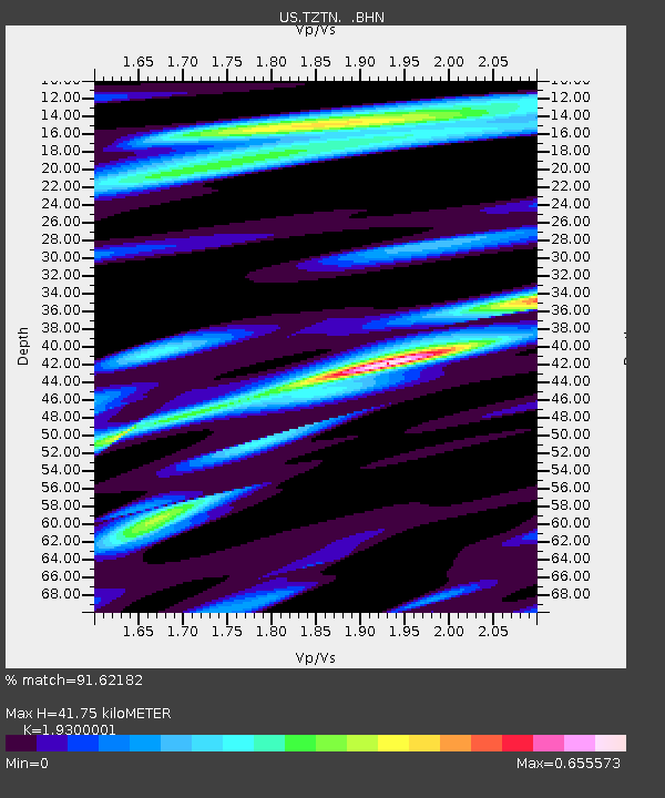
| Estimated Moho Depth: |
41.75 km |
| Estimated Crust Vp/Vs: |
1.93 |
| Assumed Crust Vp: |
6.476 km/s |
| Estimated Crust Vs: |
3.355 km/s |
| Estimated Crust Poisson's Ratio: |
0.32 |
|
| Radial Match: |
91.62182 % |
| Radial Bump: |
400 |
| Transverse Match: |
76.024506 % |
| Transverse Bump: |
400 |
| SOD ConfigId: |
2504 |
| Insert Time: |
2010-03-05 06:30:06.606 +0000 |
| GWidth: |
2.5 |
| Max Bumps: |
400 |
| Tol: |
0.001 |
|

Signal To Noise
| Channel | StoN | STA | LTA |
| US:TZTN: :BHN:20080523T19:44:20.440Z | 7.981092 | 1.0009082E-6 | 1.2540994E-7 |
| US:TZTN: :BHE:20080523T19:44:20.440Z | 3.1460435 | 2.057078E-7 | 6.5386196E-8 |
| US:TZTN: :BHZ:20080523T19:44:20.440Z | 4.292055 | 2.2894855E-7 | 5.3342408E-8 |
| Arrivals |
| Ps | 6.3 SECOND |
| PpPs | 18 SECOND |
| PsPs/PpSs | 24 SECOND |


