You are here: Home > Network List > US - United States National Seismic Network Stations List
> Station TZTN Tazewell, Tennessee, USA > Earthquake Result Viewer
TZTN Tazewell, Tennessee, USA - Earthquake Result Viewer
| Earthquake location: |
East Of Kuril Islands |
| Earthquake latitude/longitude: |
46.9/155.2 |
| Earthquake time(UTC): |
2009/01/15 (015) 17:49:39 GMT |
| Earthquake Depth: |
36 km |
| Earthquake Magnitude: |
6.9 MB, 7.5 MS, 7.4 MW, 7.4 MW |
| Earthquake Catalog/Contributor: |
WHDF/NEIC |
|
| Network: |
US United States National Seismic Network |
| Station: |
TZTN Tazewell, Tennessee, USA |
| Lat/Lon: |
36.54 N/83.55 W |
| Elevation: |
394 m |
|
| Distance: |
81.7 deg |
| Az: |
44.058 deg |
| Baz: |
323.659 deg |
| Ray Param: |
0.047341455 |
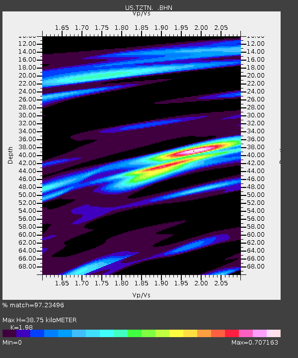
| Estimated Moho Depth: |
38.75 km |
| Estimated Crust Vp/Vs: |
1.98 |
| Assumed Crust Vp: |
6.476 km/s |
| Estimated Crust Vs: |
3.271 km/s |
| Estimated Crust Poisson's Ratio: |
0.33 |
|
| Radial Match: |
97.23496 % |
| Radial Bump: |
323 |
| Transverse Match: |
89.260185 % |
| Transverse Bump: |
400 |
| SOD ConfigId: |
2834 |
| Insert Time: |
2010-03-05 06:30:12.640 +0000 |
| GWidth: |
2.5 |
| Max Bumps: |
400 |
| Tol: |
0.001 |
|
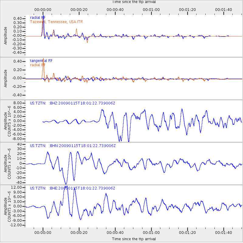
Signal To Noise
| Channel | StoN | STA | LTA |
| US:TZTN: :BHN:20090115T18:01:22.739006Z | 22.028347 | 1.235701E-5 | 5.609595E-7 |
| US:TZTN: :BHE:20090115T18:01:22.739006Z | 11.173238 | 3.926077E-6 | 3.5138225E-7 |
| US:TZTN: :BHZ:20090115T18:01:22.739006Z | 5.8148794 | 2.847943E-6 | 4.897682E-7 |
| Arrivals |
| Ps | 6.0 SECOND |
| PpPs | 17 SECOND |
| PsPs/PpSs | 23 SECOND |


