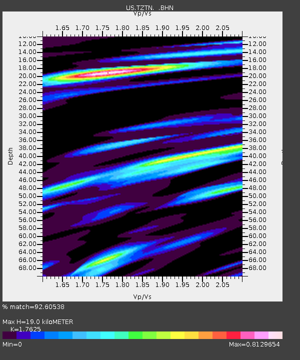
TZTN Tazewell, Tennessee, USA - Earthquake Result Viewer

Earthquake location: Near East Coast Of Honshu, Japan
Earthquake latitude/longitude: 38.3/142.0
Earthquake time(UTC): 2005/08/16 (228) 02:46:28 GMT
Earthquake Depth: 36 km
Earthquake Magnitude: 6.5 MB, 6.8 MS, 7.2 MW, 7.1 MW
Earthquake Catalog/Contributor: WHDF/NEIC
Network: US United States National Seismic Network
Station: TZTN Tazewell, Tennessee, USA
Lat/Lon: 36.54 N/83.55 W
Elevation: 394 m
Distance: 94.5 deg
Az: 35.24 deg
Baz: 325.672 deg
Ray Param: 0.04102268
Estimated Moho Depth: 19.0 km
Estimated Crust Vp/Vs: 1.76
Assumed Crust Vp: 6.476 km/s
Estimated Crust Vs: 3.674 km/s
Estimated Crust Poisson's Ratio: 0.26
Radial Match: 92.60538 %
Radial Bump: 400
Transverse Match: 82.74087 %
Transverse Bump: 400
SOD ConfigId: 110165
Insert Time: 2010-03-05 06:30:14.025 +0000
GWidth: 2.5
Max Bumps: 400
Tol: 0.001

Signal To Noise

ChannelStoNSTALTA
US:TZTN: :BHN:20050816T02:59:13.439001Z2.69228722.2171596E-78.235227E-8
US:TZTN: :BHE:20050816T02:59:13.439001Z2.2890621.7114978E-77.476852E-8
US:TZTN: :BHZ:20050816T02:59:13.439001Z7.72334868.3295765E-71.0784929E-7
Arrivals
Ps2.3 SECOND
PpPs7.9 SECOND
PsPs/PpSs10 SECOND