You are here: Home > Network List > UW - Pacific Northwest Regional Seismic Network Stations List
> Station LEBA Lebam, WA, USA > Earthquake Result Viewer
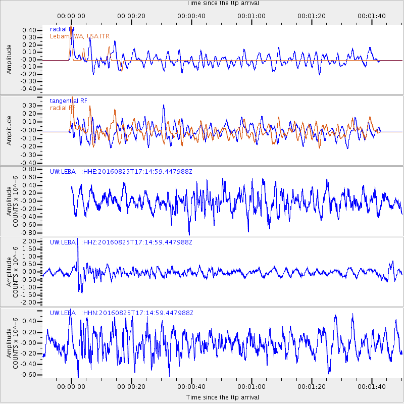
LEBA Lebam, WA, USA - Earthquake Result Viewer
*The percent match for this event was below the threshold and hence no stack was calculated.
| Earthquake location: |
Southeast Of Honshu, Japan |
| Earthquake latitude/longitude: |
30.6/137.8 |
| Earthquake time(UTC): |
2016/08/25 (238) 17:04:43 GMT |
| Earthquake Depth: |
456 km |
| Earthquake Magnitude: |
5.9 MWW, 5.9 MWB |
| Earthquake Catalog/Contributor: |
NEIC PDE/NEIC COMCAT |
|
| Network: |
UW Pacific Northwest Regional Seismic Network |
| Station: |
LEBA Lebam, WA, USA |
| Lat/Lon: |
46.55 N/123.56 W |
| Elevation: |
73 m |
|
| Distance: |
73.9 deg |
| Az: |
45.269 deg |
| Baz: |
297.457 deg |
| Ray Param: |
$rayparam |
*The percent match for this event was below the threshold and hence was not used in the summary stack. |
|
| Radial Match: |
54.45186 % |
| Radial Bump: |
400 |
| Transverse Match: |
54.883404 % |
| Transverse Bump: |
400 |
| SOD ConfigId: |
11737051 |
| Insert Time: |
2019-04-25 09:07:17.012 +0000 |
| GWidth: |
2.5 |
| Max Bumps: |
400 |
| Tol: |
0.001 |
|
Signal To Noise
| Channel | StoN | STA | LTA |
| UW:LEBA: :HHZ:20160825T17:14:59.447988Z | 5.227278 | 6.9812336E-7 | 1.335539E-7 |
| UW:LEBA: :HHN:20160825T17:14:59.447988Z | 1.7869883 | 3.0390993E-7 | 1.7006823E-7 |
| UW:LEBA: :HHE:20160825T17:14:59.447988Z | 1.1238807 | 2.1161395E-7 | 1.8828862E-7 |
| Arrivals |
| Ps | |
| PpPs | |
| PsPs/PpSs | |


