You are here: Home > Network List > US - United States National Seismic Network Stations List
> Station TZTN Tazewell, Tennessee, USA > Earthquake Result Viewer
TZTN Tazewell, Tennessee, USA - Earthquake Result Viewer
| Earthquake location: |
Easter Island Region |
| Earthquake latitude/longitude: |
-23.8/-111.7 |
| Earthquake time(UTC): |
2005/07/11 (192) 12:01:35 GMT |
| Earthquake Depth: |
10 km |
| Earthquake Magnitude: |
6.0 MB, 5.4 MS, 5.8 MW, 5.8 MW |
| Earthquake Catalog/Contributor: |
WHDF/NEIC |
|
| Network: |
US United States National Seismic Network |
| Station: |
TZTN Tazewell, Tennessee, USA |
| Lat/Lon: |
36.54 N/83.55 W |
| Elevation: |
394 m |
|
| Distance: |
65.6 deg |
| Az: |
24.631 deg |
| Baz: |
208.292 deg |
| Ray Param: |
0.058133546 |
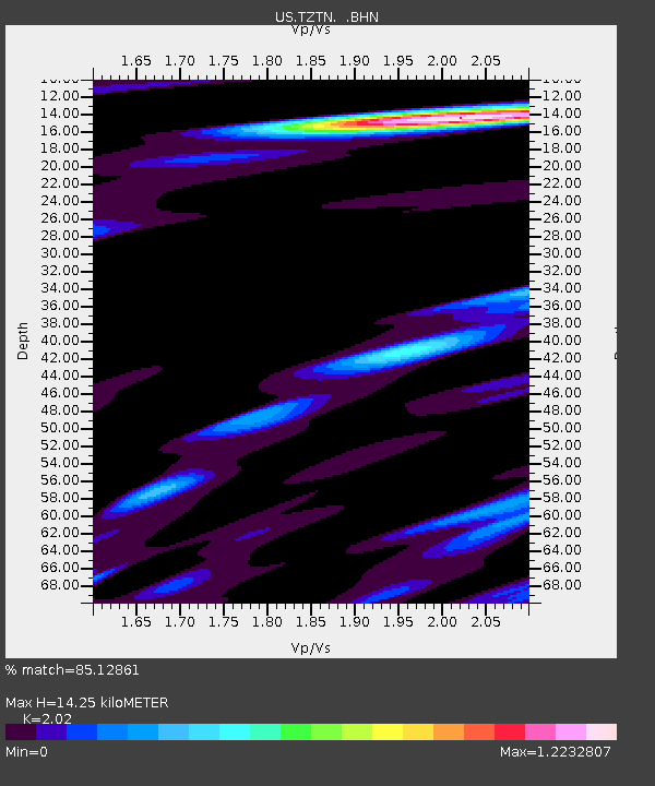
| Estimated Moho Depth: |
14.25 km |
| Estimated Crust Vp/Vs: |
2.02 |
| Assumed Crust Vp: |
6.476 km/s |
| Estimated Crust Vs: |
3.206 km/s |
| Estimated Crust Poisson's Ratio: |
0.34 |
|
| Radial Match: |
85.12861 % |
| Radial Bump: |
371 |
| Transverse Match: |
58.179974 % |
| Transverse Bump: |
400 |
| SOD ConfigId: |
110165 |
| Insert Time: |
2010-03-05 06:30:20.754 +0000 |
| GWidth: |
2.5 |
| Max Bumps: |
400 |
| Tol: |
0.001 |
|

Signal To Noise
| Channel | StoN | STA | LTA |
| US:TZTN: :BHN:20050711T12:11:48.339009Z | 2.40266 | 2.835803E-7 | 1.1802765E-7 |
| US:TZTN: :BHE:20050711T12:11:48.339009Z | 2.7367036 | 2.4599998E-7 | 8.988916E-8 |
| US:TZTN: :BHZ:20050711T12:11:48.339009Z | 3.3428106 | 9.851946E-7 | 2.9472042E-7 |
| Arrivals |
| Ps | 2.3 SECOND |
| PpPs | 6.4 SECOND |
| PsPs/PpSs | 8.7 SECOND |


