You are here: Home > Network List > US - United States National Seismic Network Stations List
> Station TZTN Tazewell, Tennessee, USA > Earthquake Result Viewer
TZTN Tazewell, Tennessee, USA - Earthquake Result Viewer
| Earthquake location: |
Northern Mid-Atlantic Ridge |
| Earthquake latitude/longitude: |
47.0/-27.3 |
| Earthquake time(UTC): |
2008/12/19 (354) 08:31:51 GMT |
| Earthquake Depth: |
2.0 km |
| Earthquake Magnitude: |
5.8 MB, 5.6 MS, 5.9 MW, 5.8 MW |
| Earthquake Catalog/Contributor: |
WHDF/NEIC |
|
| Network: |
US United States National Seismic Network |
| Station: |
TZTN Tazewell, Tennessee, USA |
| Lat/Lon: |
36.54 N/83.55 W |
| Elevation: |
394 m |
|
| Distance: |
42.4 deg |
| Az: |
276.784 deg |
| Baz: |
57.56 deg |
| Ray Param: |
0.073212124 |
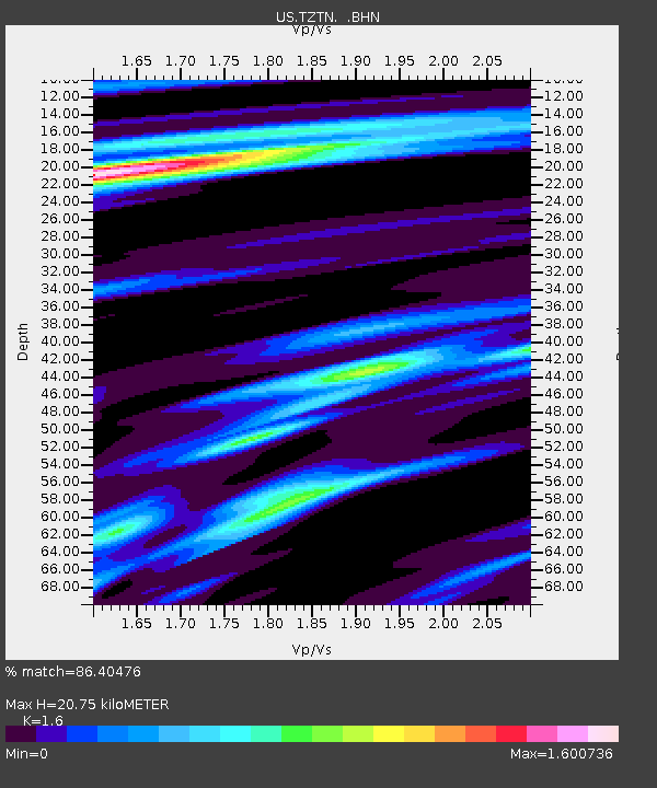
| Estimated Moho Depth: |
20.75 km |
| Estimated Crust Vp/Vs: |
1.60 |
| Assumed Crust Vp: |
6.476 km/s |
| Estimated Crust Vs: |
4.047 km/s |
| Estimated Crust Poisson's Ratio: |
0.18 |
|
| Radial Match: |
86.40476 % |
| Radial Bump: |
298 |
| Transverse Match: |
61.821598 % |
| Transverse Bump: |
400 |
| SOD ConfigId: |
2658 |
| Insert Time: |
2010-03-05 06:30:36.485 +0000 |
| GWidth: |
2.5 |
| Max Bumps: |
400 |
| Tol: |
0.001 |
|

Signal To Noise
| Channel | StoN | STA | LTA |
| US:TZTN: :BHN:20081219T08:39:15.990001Z | 4.058671 | 7.4731105E-7 | 1.8412705E-7 |
| US:TZTN: :BHE:20081219T08:39:15.990001Z | 2.157639 | 2.1591086E-7 | 1.00068114E-7 |
| US:TZTN: :BHZ:20081219T08:39:15.990001Z | 2.8004022 | 3.7446253E-7 | 1.337174E-7 |
| Arrivals |
| Ps | 2.1 SECOND |
| PpPs | 7.7 SECOND |
| PsPs/PpSs | 9.8 SECOND |


