You are here: Home > Network List > IU - Global Seismograph Network (GSN - IRIS/USGS) Stations List
> Station PAYG Puerto Ayora, Galapagos Islands > Earthquake Result Viewer
PAYG Puerto Ayora, Galapagos Islands - Earthquake Result Viewer
| Earthquake location: |
Near Coast Of Central Chile |
| Earthquake latitude/longitude: |
-31.6/-71.7 |
| Earthquake time(UTC): |
2015/09/21 (264) 05:39:33 GMT |
| Earthquake Depth: |
23 km |
| Earthquake Magnitude: |
6.3 MWP |
| Earthquake Catalog/Contributor: |
NEIC PDE/NEIC COMCAT |
|
| Network: |
IU Global Seismograph Network (GSN - IRIS/USGS) |
| Station: |
PAYG Puerto Ayora, Galapagos Islands |
| Lat/Lon: |
0.67 S/90.29 W |
| Elevation: |
270 m |
|
| Distance: |
35.4 deg |
| Az: |
326.655 deg |
| Baz: |
152.021 deg |
| Ray Param: |
0.07720521 |
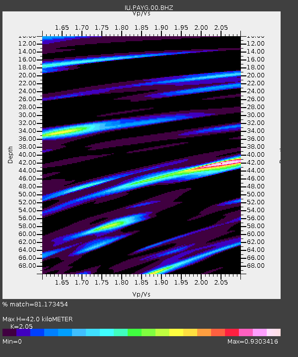
| Estimated Moho Depth: |
42.0 km |
| Estimated Crust Vp/Vs: |
2.05 |
| Assumed Crust Vp: |
4.802 km/s |
| Estimated Crust Vs: |
2.342 km/s |
| Estimated Crust Poisson's Ratio: |
0.34 |
|
| Radial Match: |
81.173454 % |
| Radial Bump: |
400 |
| Transverse Match: |
57.44383 % |
| Transverse Bump: |
400 |
| SOD ConfigId: |
1156111 |
| Insert Time: |
2015-10-05 06:26:53.361 +0000 |
| GWidth: |
2.5 |
| Max Bumps: |
400 |
| Tol: |
0.001 |
|
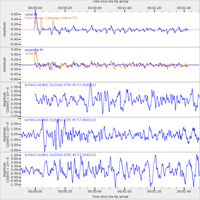
Signal To Noise
| Channel | StoN | STA | LTA |
| IU:PAYG:00:BHZ:20150921T05:45:57.069012Z | 2.793603 | 9.365193E-7 | 3.352371E-7 |
| IU:PAYG:00:BH1:20150921T05:45:57.069012Z | 1.0880382 | 1.974663E-7 | 1.814884E-7 |
| IU:PAYG:00:BH2:20150921T05:45:57.069012Z | 1.2326308 | 5.0357596E-7 | 4.0853752E-7 |
| Arrivals |
| Ps | 9.5 SECOND |
| PpPs | 26 SECOND |
| PsPs/PpSs | 35 SECOND |


